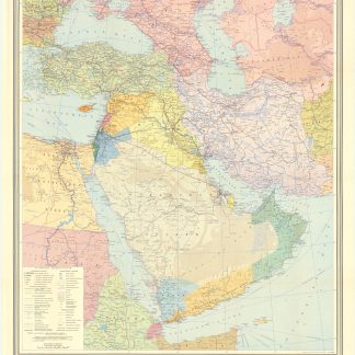
Map of Iran and Iraq in the 1930s
Iran (Persia) and Iraq.
London, George Philip & sons, [1930s].
Colour printed map, 540 x 680 mm, with yellow covers (195 x 110 mm).
€ 650,00
Map of Iran, Iraq and parts of the surrounding countries, including modern Kuwait, Bahrain, Qatar and the UAE, in the 1930s, published in the series "Philips' authentic imperial maps for tourists & travellers". Published in the early years of the discovery of oil in the Middle East, the map shows roads and railways, but also caravan routes, submarine cables and oil pipelines.
Slightly soiled, in very good condition.