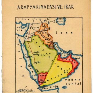
Arap Yarimadasi ve Irak.
[Istanbul, ca. 1929].
Ca. 280 x 200 mm. Manuscript map of the Arabian Peninsula and Iraq in original hand colour. Captioned in Turkish (in Latin letters).
€ 800,00
Unique hand-drawn map of the Arabian Peninsula and Iraq by the Turkish cartographer, scientist and cadastre specialist Halid Ziya Türkkan, who was appointed Head of the Science Committee of Istanbul's new cadastre office in 1925. The map distinguishes Nejd, Yemen, Hadramaut, Oman, Kuwait, and Iraq by different colours, also showing the Bay of Aden, the Umman Sea, and the Red Sea. Featured cities include Aden, Makkah, Medina, Sana'a, and Mascat.
Signed in ink by the cartographer. Very well preserved.