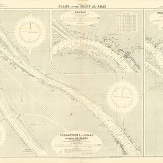
Plans in the Shatt Al Arab. 1250.
London, published at the Admiralty, 1926.
1030 x 700 mm.
€ 850.00
Chart showing "Quarantine Island to Coal Island including Al Basra" (scale 1:10,000), "Abadan" (scale 1:12,500) and "Mohammerah Bar" (scale 1:12,500) including tidal information, compass roses, soundings, seabed notations, currents, sandbanks, lighthouses and beacons marked in orange, inland elevations, detailing and buildings. First published in 1921, revised in 1926. Signs of contemporary use. Folded.