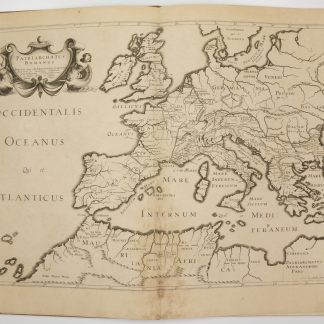
Analisi storico-topografico antiquaria della carta de' dintorni di Roma.
Large 8vo. 3 vols. (8), XLVIII, (2), 564 pp., with a folding letterpress table opposite p. 353. 678 pp., final blank. 759, (1) pp. Contemporary full vellum with double giltstamped labels to elaborately gilt spines; all edges sprinkled. Ribbon markers.
€ 800.00
First edition, based on Sir William Gell's 1827 map of the Campagna (not included with the set). "Ouvrage des plus importants sur les environs de Rome et fruit d'un travail immense puisque les recherches topographiques et historiques de l'auteur, conduites avec sa maîtrise habituelle, s'étendent aux plus obscurs coins de la campagne romaine. Cela fait que cet ouvrage est encore recherché et toujours cité" (Olschki). Occasional slight foxing. A fine copy from the library of the Ducs de Luynes at the Château de Dampierre: their bookplate reproducing the arms of Charles Marie d'Albert de Luynes (1783-1839), 7th Duc de Luynes, on pastedown.
Olschki 17654. Brunet VI, 25585. ICCU RMR\0261953. Not in Schudt.