The principal harbours of the Mediterranean
Recueil de 163 principaux plans des ports et rades de la Mediterranée.
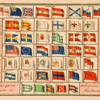
Oblong 4to. Coloured engraving of flags (civil and war ensigns) as frontispiece, engraved title page and 163 engaved maps (some lightly coloured). With 2 letterpress pp. of index at the end and a folding engr. plan of the harbor of Odessa (not belonging to this work). Contemprary half calf.
€ 7,500.00
Pocket-size atlas of the principal harbour installations and bays of the Mediterranean, many of which at the time were still in Ottoman possession. They include numerous ports on the Barbary Coast (Tanger, Oran, Algiers, Tunis, Monastir, Sfax, Tripoli, Bengasi, Essaouira), the Greek islands, and the Eastern coast of the Mediterranean (Beirut, Tyre).
Long the principal route for merchants and travellers between Europe and the East, allowing for trade and cultural exchange between the many peoples of the region, the development of a sea route to the Indian Ocean from the late 15th century onwards made possible the importation of Asian spices and other goods through the Atlantic ports of western Europe and diminished the importance of the Mediterranean route. Only in the second half of the 19th century would it once more become an important passageway for goods and travellers: after the opening of the Suez Canal half a century after the present publication, it enabled ships to reach the Eastern world in record time, with dramatic effects on world trade.
Binding slightly rubbed; handwritten ownership "L. Falciola" on flyleaf. A good, clean copy, formerly in the Ottoman collection of the Swiss industrialist Herry W. Schaefer.
Scheepvaart Mus. 62. OCLC 560616922. Cf. Phillips 196, 3974 & 5172; Zacharakis 1967-2040 (other eds.).
Related
-
An Account of the Empire of Marocco, and the District of Suse.London, 1809.
€ 1,500.00 -
Voyage de la Propontide et du Pont-Euxin.Paris, 1800-1802.
€ 3,500.00 -

Reisen oder Anmerkungen verschiedene Theile der Barbarey und der Levante …Leipzig, 1765.
€ 2,000.00 -
Wilayat yawlalaa kharituh sydur [Road Maps of the Vilayets].Istanbul, 1913 CE = 1329 Rumi.
€ 35,000.00