Imperii Persici in omnes suas provincias.
Nuremberg, ca. 1720.
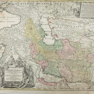
Hand-coloured engraved map (615 x 523 mm).
€ 1,800.00
Detailed map of the region bounded by the Gulf of Basra and the Indian Ocean in the South, Indus River and Turckestan in the East, Astracan, Circcasia and the Crimea in the north and the Black Sea and Cyprus in the West, centered on the Caspian Sea. Decorative map, showing cities, mountains, rivers, lakes, roads, etc. Large decorative cartouche and smaller cartouche. Marvelous detail throughout. One of the few commercial atlas maps to focus closely on this region at the beginning of the 18th Century.
Slightly brownstained and dusted.
References
Not in Tibbetts.