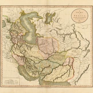
A New Map of Persia, from the Latest Authorities.
London, 1811.
Hand-coloured engraved map (515 x 470 mm).
€ 950.00
A highly detailed late 18th Century map of Persia, from an early edition of Cary's atlas. Offers extraordinary detail regarding cities, trade routes and physical geography. In some cases Cary offers annotations on important battle sites and on the ruins of ancient Mesopotamian cities.
A near fine example in beautiful wash color.
References
Al-Qasimi 217.
Related
-
Der Nahe Osten. Tornisterschrift des NS.-Führungsstabes der Wehrmacht. …Berlin, 1944.
€ 350.00 -
Naukeurige beschryving van Asie: behelsende de gewesten van Mesopotamie, …Amsterdam, 1680.
€ 8,500.00 -

Reize naar Arabië en andere omliggende landen.Amsterdam & Utrecht, 1776-1780.
€ 6,000.00 -

Iran (Persia) and Iraq.London, 1930s.
€ 650.00