

USAF pilot's map of the Arabian Gulf
Persian Gulf. ONC-H-6/7. Operational navigation chart.
St. Louis, Aeronautical Chart and Information Center, United States Air Force, 1967.
Map, colour-printed on two sides of a sheet of silk (1030 x 785 mm). Scale 1:1,000,000.
€ 1,500.00
Rayon pilot's map of the Arabian Gulf region focusing on the Trucial States (modern UAE), Qatar, Bahrain, Oman, Iran and Saudi Arabia, including main oil installations. Items of specific interest to aircraft, such as airfields and even seaplane bases, are particularly listed. Warnings to stay within the specific flying routes while in Iran are placed on multiple locations.
Slightly frayed at the edges. In very good condition.
Related
-
The Geographical Journal. Vol. IV, No. 2.London, 1894.
€ 500.00 -

Voyage en Arabie & en d'autres Pays circonvoisins. Tome premier (-second). …Amsterdam & Utrecht, 1775-1780.
€ 6,000.00 -
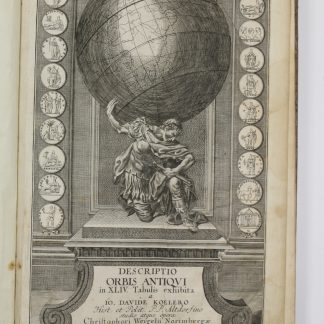
Descriptio orbis antiqui in XLIV tabulis exhibita.Nuremberg, ca. 1720.
€ 3,800.00 -

Iran (Persia) and Iraq.London, 1930s.
€ 650.00