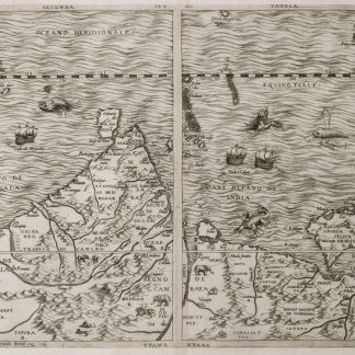
The 16th century's most accurate map of India and the Gulf region
Seconda tavola.
Engraved map of the Indian Ocean, Indian subcontinent and most of the Gulf region (28 x 39 cm; margins extended to 50 x 66.5 cm), at a scale of about 1:13,500,000 with north at the foot, with the equator reticulated with longitudes based on a prime meridian through Cape Verde, reticulated scales of latitude in the left and right borders, the Tropic of Cancer not reticulated; 3 sea monsters, a spouting whale and 3 ships in the ocean; and on the land elephants, lions and 2 people on horseback carrying spears.
€ 18,000.00
Rare very early engraved map showing the Indian subcontinent, the Strait of Hormuz, the eastern half of the Gulf, and the Indian Ocean, including the islands of Ceylon (Sri Lanka), the Maldives, Seychelles, the western tip of Sumatra and what must be the eastern tip of Somalia. The island Diego Garcia (7° S), labelled "Isole de Don Garzia", touches the southern edge of the map image. The map's own scales indicate that it covers 35°N to 9°S and 60 to 120°E (labelled 85 to 145°E following the Cape Verde prime meridian), but in fact it covers about 60 to 96°E. It is double trapezoidal projection, but tapers only slightly from its widest point at the equator. Many topographic names appear in forms used in early Portuguese accounts of voyages, but most can be identified. In India and Ceylon we find Goa, Mangalor (Mangalore), Cochin (Kochi), Calinapata (Calcutta?), Besinagar (Bangalore), Colmucho (Colombo) and many others; in the Gulf region Cor. Dulfar (Dhofar), the island Macira (Masirah), C. Resalgate (Ras el Had?), Galatia (the ancient site Qalhat), Mazcate (Muscat), the island Quexumo (Qeshm) and Ormus (Hormuz). There is even an unlabelled city close to present-day Abu Dhabi. Two of the ships are labelled with their destinations: Calicut (Kozhikode) on the Malabar Coast and Molucche (the Moluccas) in the East Indies.
Gastaldi first published a similar map as one of a set of three woodcut maps in the first volume of the second edition of Giovanni Battista Ramusio,Navagationi et viaggi, Venice, 1554: the "Prima tavola" shows Africa, the "Seconda tavola" shows the regions in the present map and the "Terza tavola" shows Southeast Asia and the East Indies. These were a great advance on earlier maps, including even Gastaldi's own, taking account of new information from Portuguese explorers.
The woodblocks and whatever copies of the printed edition had not yet been sold were destroyed by a fire in 1557, so for the 1563 edition the publisher had the three maps engraved on copperplates by Niccolo Nelli. Bertelli published the three maps without Ramusio's text, and his maps are usually supposed to have been printed from the 1563 plates, but Karrow describes them as close copies, with his name and the date 1565 added in each map, and Bertelli was an engraver as well as a publisher. Although the first map also has a longer note referring to all three maps, they were probably issued separately as well. Although printed from a single copper plate, the present map image is divided into two parts, with a 7 mm gap between the right and left halves, so that nothing would be lost if the map were bound as a double-page plate. No later state is noted in the literature, so there may have been multiple printings with the unrevised plate.
The present copy is printed on a whole sheet of paper, watermarked: coat of arms (77 x 44 mm) bearing a tree on the central and highest of three hills = --, with about 38.5 mm between chainlines except that the mark is centred on a chainline only 25 mm from the adjacent ones. The tree clearly matches the style of the oak tree in the arms of the family Delle Rovère, including the Popes Sixtus IV and Julius II (who served 1471-1484 and 1503-1513), but their arms does not include the hills. The present mark is very close to Briquet 969 (Lucca 1573-1582) and Zonghi 1737 (Fabriano 1571). Likhachev 3636 (an Italian manuscript f ca. 1570) is not as close. All similar marks noted in the literature date from the period 1569 to 1582, so the present map seems unlikely to have been printed in 1565, but very likely to have been printed ca. 1570 (Bertelli remained active to ca. 1580 or perhaps even later). Bifolco & Ronca lists copies of the 1563 (84a) and the present 1565 (84b) state or edition together, but their separate lists of references suggest the present 1565 version is much rarer.
The margins have been cut down close to the plate edge and in places to the outer edge of the border, and the margins then greatly extended (10-14 cm) with blank paper, but this paper is also contemporary, watermarked: coat of arms bearing a ladder and topped with a 6-point star (90 x 27 mm) = --, similar to Likachev 3524 (Loreto 1564). The map is very slightly browned at the edges (where the pieces of paper used to extend the margins were pasted together) and in the gap between the right and left halves (where the old fold has been reinforced on the back), but the map is otherwise in fine condition. A milestone in the cartography of India and the Gulf States, remarkably well preserved.
Bifolco & Ronca, Cartografia topografia Italiana, 84b. Gole, Early printed maps of India, 2. Karrow 30/74.2.
Related
-
The Navigation and v[o]yages of Lewes Vertomannus, Gentelman of the citie …London, 1577.
€ 265,000.00 -
A Series of Lithographic Drawings from Sketches by Robert Clive, comprising …London, 1852.
€ 18,000.00 -
Arab States of the Lower Gulf: People, Politics, Petroleum.Washington D.C., 1975.
€ 250.00 -
Around the Coasts of Arabia.London , 1930.
€ 1,500.00