
Asien.
254 x 201 mm. Lithographed map. Scale 1:50,000,000. Gilt wooden frame (290 x 357 mm).
€ 60.00
Political map of Asia prior to WWI, showing the Arabian Peninsula and the Gulf, the Ottoman Empire, Russia, China, India, Japan, and South East Asia, including the Philppines and Indonesia, as well as large parts of Europe and the westernmost part of Africa. With an inset map of Tokyo and its surroundings (1:500,000).
Early edition of Eduard Gaebler's map of Asia, published in "Neuester Hand-Atlas über alle Teile der Erde" (Leipzig, Gaebler's Geographisches Institut, 1892). The map saw numerous reissues; a slightly revised edition appeared in Gaebler's "Kleiner Handatlas" as late as 1933.
Slightly foxed. Frame with some traces of worming. An appealing map in an attractive wooden frame with a gilt border.
Related
-

Reize naar Arabië en andere omliggende landen.Amsterdam & Utrecht, 1776-1780.
€ 6,000.00 -
Karte von Asien. [Map of Asia].Vienna, 1786.
€ 2,500.00 -
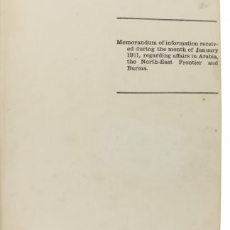
Memorandum of information received during the month of January [-December] …Calcutta, 1911.
€ 25,000.00 -
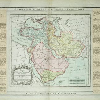
Perse, Turquie Asiatique et Arabie.Paris, 1799.
€ 450.00