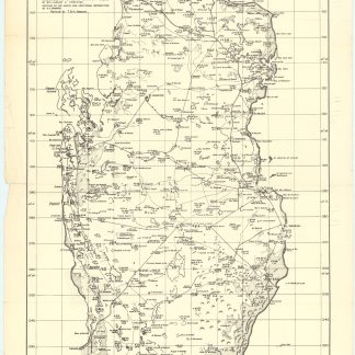
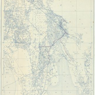
Blueprint map of the Gulf
Dhahran. Scale 1:500,000.
985 x 645 mm. Scale 1:500,000. Key in English. Printed on cloth.
€ 5,000.00
Blueprint map of the Gulf, showing Saudi Arabia, Bahrain, and parts of Qatar. The map pays particular interest to oil and gas exploration, detailing the Trans-Arabian Pipeline, the old tapline survey route, and the offshore terminal and refinery at Ras Tanura, as well as the Jafurah basin, the largest natural gas field in the Kingdom stretching 170 by 100 kilometers.
Among the most notable places are Hofuf, Dhahran, and Abqaiq in Saudi Arabia, as well as Manama, Awali, and al-Muharraq in Bahrain. Labelled locations in the displayed portion of Qatar's coast include Hawar Island, Dukhan and Salwa. The map illustrates trails, roads, and airstrips, as well as topographical features such as dunes, sand and gravel patches, and sabkhas.
The sheet was prepared as a working document by Aramco and the U.S. Geological Survey to help them in the early stages of comprehensive nationwide mapping and exploration work for the Saudi Government. First published in May 1953, the present map was revised in February 1954.
Two minor brown spots; upper left edge a little toned and frayed.