Malerisch-technischer Atlas der k. k. Staatseisenbahn-Strecke von Mürzzuschlag bis Gratz in Steiermark [...].
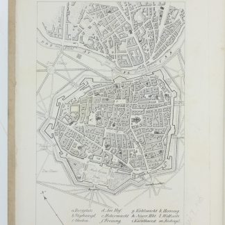
4to. 24 pp. With 2 tables, one of which folding, a lithographed folding plan depicting 14 train stations, a large folding panoramic view of the railway track with 14 smaller marginal views, and a folding view of architectural monuments, mainly railway bridges. With lithographed plans of Vienna and Graz to pastedowns. Original printed boards.
€ 600.00
Illustrated description of the newly established railway between Mürzzuschlag and Graz, which opened on 21 October 1844. Prepared by the Paris-born railway engineer Demarteau, this work reflects the importance of the Südbahn - a railway project that promised economic prosperity to southern Austria and, upon its completion in 1854, resulted in a continuous railway track from Vienna to Ljubljana. The "Atlas" is particularly remarkable for its fine lithographs, prepared by August Grube in Vienna, some after designs by Rudolf von Alt and F. Weiss. The large folding panorama of the track, including an elevational and longitudinal profile, is decorated with charming views of the towns of Semmering, Krieglach, Langenwang, Kindberg, Kapfenberg, Bruck, Peggau, Judendorf-Straßengel and Graz. Views of prominent railway bridges and station buildings, as well as plans of the 14 stations along the route from Mürzzuschlag to Graz, complete the picture. In addition, the work gives an introduction to the history of Styria and the construction of the track.
The 24-page introduction and the two tables are included in French in a separate booklet at the end of the volume. The French title is given on the lower board.
Binding very slightly duststained, still a fine copy of an uncommon work.
Schlossar 100. Nebehay/Wagner 140. Metzeltin 884. Neuner 961.