1970s tourist map of the UAE, Qatar and Bahrain
The United Arab Emirates. Tourist Map.
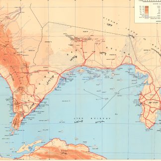
Colour-printed map, 590 x 780 mm. Scale 1:1,125,000. In English and Arabic.
€ 1.500,00
Tourist map of the United Arab Emirates, Qatar and Bahrain, including portions of Saudi Arabia and Oman, as well as the coast of Iran. Apart from primary and secondary roads, proposed roads and roads under construction, the map indicates major cities such as Al Manamah, Doha, Abu Dhabi, Dubai, Sharjah, Umm Al Qaiwain, Ras Al-Khaimah, Al-Fujairah and Muscat. Includes ports, aiports, wadis, wells, pipelines, oilfields, sand plains, areas of silt, and sabkhas. With seven city maps (Abu Dhabi, Sharjah, Dubai, Ras Al-Khaimah, Umm Al-Qaiwain, Al-Fujairah, Ajman), and points of interest in the Emirates on the reverse.
A few small marginal tears.
OCLC 500873785.