With 40 maps surveying the Indian subcontinent
General Report on the Operations of the Survey of India Department Administered Under the Government of India During 1896-97.
Folio (214 x 339 mm). V, (1), 105, (1), LVI, (2), 4 pp. With 40 colour-printed maps and plates, including 13 folding maps (the largest two 550 x 620 mm and 610 x 750, respectively) and 4 photo-engraved plates. Original printed boards, rebacked with library cloth spine and original cloth spine title mounted.
€ 6.500,00
First edition, scarce. The 1896-97 report on the British's Survey of India program, which mapped as never before the Indian subcontinent under British rule. Proposed and begun shortly after the British East India Company defeated Tipu Sultan, their longtime rival and the main force blocking British expansion, the survey was predicted to take some five years, and ended up spanning seventy. In this time, British control of India passed from the East India Company to the crown itself, which remained anxious to survey the colonized land from which it drew incredible wealth. The survey was the first to map the Himalaya, established Everest as the tallest mountain in the world, and pushed forward survey technology and mapping throughout the 19th century.
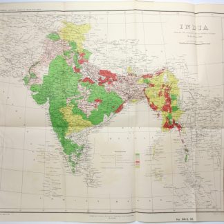
This scarce volume, of which OCLC lists a single physical copy (at Howard College, UKZN, Durban, South Africa), was edited under the direction of Major-General Charles Strahan (1843-1930), R.E., Surveyor-General of India. It comes from the close of the century and boasts 40 maps and plates of British India showing the extent of the land covered by the Great Trigonometric Survey and the Survey of India, which by this point had become joint ventures.
While most plates are maps, four are photo-engravings of high quality, including the frontispiece showing the 1898 total solar eclipse (the first photograph of a solar eclipse had been taken less than 50 years earlier), a photograph of the eclipse photography team, and two photographs of the 1897 earthquake. The two largest maps show "the Progress of the imperial surveys to 1st October 1897" and "Index Chart to the Great Trigometrical Survey of India", both of which track the overall progress across the subcontinent.
With the aquisition and cancellation stamps of the London Library (acquisition dated "12. Nov. 98").
Light wear; library marks, including London Library sticker on front cover. In good condition.
OCLC 896603904.
Ähnlich
-
Naukeurige beschryving van Asie: behelsende de gewesten van Mesopotamie, …Amsterdam, 1680.
€ 8.500,00 -
De Nili et aliorum fluminum origine.Den Haag, 1666.
€ 5.000,00 -
The Mariners Magazine. [...] Revised, corrected and enlarged by John Colson.London, 1700.
€ 8.500,00 -
Vierzig-Jährige Reise-Beschreibung. Worinnen dessen durch Türkey, Persien, …Nürnberg, 1681.
€ 8.500,00