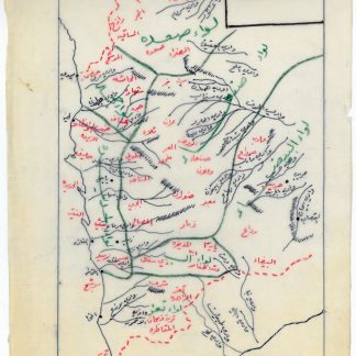
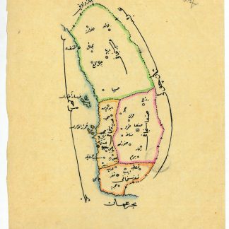
Manuscript map of Yemen Vilayet.
Ca. 230 x 190 mm. Original hand-coloured map on tissue paper. In Ottoman script and Arabic.
€ 850,00
Hand-drawn map of the Yemen vilayet, distinctly outlining the sanjaks of Sana'a, Ta'izz, Hudeyde, and Asir, bordered by the Arabian Desert, the Hejaz vilayet, the Red Sea, and the Umman Sea. Maps such as this, executed on thin tracing paper, were commonly made as educational tools at elite Ottoman schools and universities during the early 20th century, although few such specimens survive. The manuscript notes suggest that the map was used for military purposes during the last Ottoman imperial period.
At the beginning of the 20th century, the vilayet covered an area of 200,000 square kilometers, its population having reached 2,500,000 by 1885. When World War I broke out, Imam Yahya remained nominally loyal to the Sultan but at the same time strove to negotiate with Britain. Turkish forces withdrew in 1918, and Imam Yahya strengthened his control over northern Yemen, creating the Mutawakkilite Kingdom of Yemen.
Very well preserved.