Daily Express Map of the Middle East.
783 x 985 mm. Original colour printed map. Scale 1:5,000,000.
€ 650,00
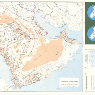
Detailed map of the Middle East, published in 1967, as international interest in the region rose in the wake of the Six-Day War. The map shows the greater Middle East, including northeast the Arabian Peninsula, Africa, Persia, and Anatolia. Pre-dating the creation of South Yemen only by a couple of months, the map labels the "Federation of South Arabia" and the "Protectorate of South Arabia" merging to become the "People's Republic of South Yemen" on 30 November 1967. South Yemen was unified with the Yemen Arab Republic, commonly known as "North Yemen", on 22 May 1990 to form the present-day Republic of Yemen. Further East, Oman is divided between the "Muscat and Oman" and "Trucial Oman" - essentially, today's UAE. A neutral zone splits Iraq from Saudi Arabia.
Particularly appealing for its bright colours and the decorative border bearing the national coats of arms of Aden, Afghanistan, Bahrain, Cyprus, Ethiopia, Iraq, Iran, Jordan, Kuwait, Lebanon, Muscat and Oman, Israel, Saudi Arabia, Sudan, Turkey, Egypt - U.A.R., Syria and Yemen.
Somewhat soiled; a few small marginal tears. A single copy in libraries worldwide (Columbia University).
OCLC 235121427.