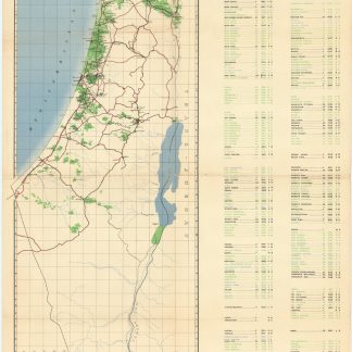
Mapped Jewish settlements funded by Keren Hayesod
Eretz Israel. Map of Jewish Settlements. Keren Hayesod Agricultural Work 1921-1946.
Chromolithograph map, 852 x 520 mm. Scale 1:500,000.
€ 950,00
A map depicting the Jewish settlements related to Keren Hayesod agricultural work from 1921 to 1946. Keren Hayesod was, during the pre-state period, a single-issue Zionist funding body and played a large role in the settlement of Palestine by Jewish colonists prior to 1948; many of these settlements were agricultural in nature. The map lists over one hundred settlements and distinguishes those established by from those aided by Keren Hayesod. Also identified are settlement types: communal, smallholders, village, urban, town, training farms, and ex-servicemen villages. A colourful and thorough overview of Keren Hayesod's work in the region.
A hint of wear along creases, otherwise well preserved.
OCLC 827860593.
Ähnlich
-
Tsemah 'Ever Ha-Yarden: mifkad bikoret li-tsemahim asher ne'esfu u-miktsatam …Zichron Yaakov, 1934.
€ 850,00 -
Zionist Policy. An Address [...] Sunday, September 21st, 1919.London, 1919.
€ 1.500,00 -
Minsharim, tsavim u-minuyim [Proclamations, Orders and Appointments] shel …Jerusalem, August-December 1967.
€ 4.800,00 -
Autograph letter signed and letter signed to the Committee of the Jews …Jerusalem, 17 May 1920 and 12 June 1924.
€ 3.500,00