"all modern maps [...] trace their roots back to these first publications" (Parry)
[United States Geological Survey of the Kingdom of Saudi Arabia].
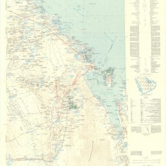
15 sheets in full colour, c. 100 x 100 cm approx., folded. 13 in original printed envelopes with individual titles, another in a later envelope, and one stored loosely. English and Arabic. Scale 1:500,000; relief shown by hachures and spot heights.
€ 5.000,00
Extensive collection of these hugely important geographico-geological maps of Saudi Arabia: the groundbreaking, fully bilingual and dual-dated series prepared by the U.S. Geological Survey and the Arabian American Oil Company under the joint sponsorship of Saudi Arabia and the U.S. State Department. The first to produce a full series of geological and geographical maps of the Kingdom of Saudi Arabia, the venture was instrumental in establishing the country as a major global force in the production of natural resources and must count as "a unique experiment in geological cooperation among several governments, petroleum companies, and individuals" (Seager/J.). The area covered also includes the territories of Bahrain and parts of Qatar. "The plan for a cooperative mapping project was originally conceived in July 1953 [... By 1955] there was established a cooperative agreement between the Kingdom of Saudi Arabia, the U.S. Department of State, and the Arabian-American Oil Co. to make available the basic areal geology as mapped by Aramco and the U.S. Geological Survey". The surveyors divided the Peninsula into 21 quadrangular sections (numbered I-200 through I-220), each to cover an area 3 degrees of longitude and 4 degrees of latitude. All maps were produced on a 1:500,000 scale and issued in two series: a combined map of geography and geology (marked by the appendix 'A') and a map of geography only ('B'). "High altitude photography [...] was [...] completed in 1959 [...] This controlled photography resulted in highly accurate geographic maps at the publication scale which then served as a base for the geologic overlay. The topography of the sedimentary areas was depicted by hachuring and that of the shield region by shaded relief utilizing the airbrush technique. The first geographic quadrangle was published in July 1956 and the last in September 1962 [...] The first of the geologic map series was published in July 1956 and the final sheet in early 1964" (ibid.).
Although it was the search for oil, gas and minerals that "was ultimately to drive geological survey work across the region [...], in its early years it was the need for water that was the catalyst for Saudi Arabia's resource exploration. In 1944 King 'Abd al-'Aziz approached the United States for a technical expert who could assist with the identification and plotting of the kingdom's natural resources, particularly its groundwater reserves [...] By 1954 the Saudi Ministry of Finance, USGS and Aramco were working together to produce the first full series of geographic and geologic maps of the country. The first of their type in the Peninsula, these were published [...] in both Arabic and English versions, and the information they contained formed the basis of subsequent Saudi national development plans" (Parry). Indeed, the project was considered highly important by Ibn Saud, and its aims encompassed all aspects of cartography. It was to enable not only the search for natural resources but also aid in advances for agriculture, civil and military engineering and general infrastructure projects. The results were seminal for the mapping of the region: "To this day, all modern maps of the kingdom trace their roots back to these first publications" (ibid.).
Of the 21 sections, 13 are covered by the present collection, which focuses on the less common geologic series: 200-202 A, 205 A&B, 206-207 A, 208 B, 212 A, 214 A, 217-220 A (219 including B). All are first editions, except 205A is present as "Geologic Map GM-205A", the 1979 reprint of "I-205A" as released in 1963.
In excellent state of preservation.
James V. Parry, "Mapping Arabia", in: Saudi Aramco World 2004/1, p. 20ff. O. A. Seager/W. D. Johnston, Foreword to the Geology of the Arabian Peninsula series (U.S. Geological Survey Professional Paper 560-A-D, 1966).
Ähnlich
-

Persian Gulf. ONC-H-6/7. Operational navigation chart.St. Louis, 1967.
€ 1.500,00 -

Iran (Persia) and Iraq.London, 1930s.
€ 650,00 -
Northern Arabia according to the original investigations of Alois Musil …New York, 1926.
€ 3.500,00 -
USAF aeronautical chart and information service. World aeronautical chart …Washington, DC, 1958.
€ 950,00