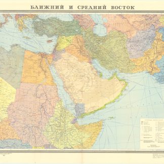
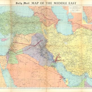
Daily Mail Map of the Middle East.
715 x 1085 mm. Colour-printed map. Scale 1:3,500,000.
€ 3.500,00
Brightly coloured map of the Middle East, showing the newly-founded United Arab Republic, Anatolia, Iraq, Iran, parts of Egypt, Israel, Jordan, Saudi Arabia, Kuwait, Bahrain, the Trucial States, Muscat and Oman. With two inset maps of the Suez Canal and the southern part of the Arabian Peninsula including Yemen and a portion of Eritrea.
Indicates international boundaries, capitals and major cities, railways, roads, shipping routes, oil pipelines and telecommunication networks. Includes an ancillary "Daily Mail Oil Map of the World" on the reverse, conjoint with bar-graphs and tables showing world oil production, export, import, and refining capacities, alongside observations on economic and political conditions of the various nations, complete with small portraits of heads of state including Gamal Abdul Nasser, King Saud of Saudi Arabia, and David Ben Gurion.
Somewhat worn along the folds; pierced in places.
OCLC 879307344.