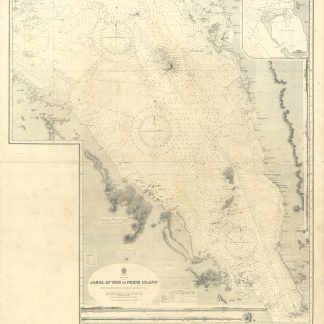
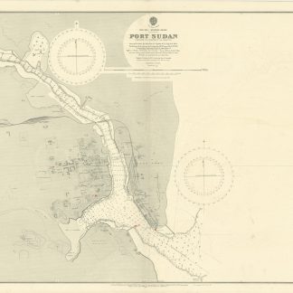
Port Sudan. No. 3492.
Standard issue, 687 x 1024 mm. Scale 1:8,100.
€ 400,00
Detailed nautical chart of Port Sudan, the primary port of Sudan, prepared by the British Admiralty. Undoubtedly one of the best maps of the young city, which was built between 1905 and 1909 by the administration of Anglo-Egyptian Sudan to replace Suakin.
The chart details numerous mooring posts, the port police, cranes and the customs office, as well as dangerous coral reefs stretching across the entire shore of Port Sudan. It includes landmarks like churches and mosques, the Governor's residence, the public garden, school, and hospital, as well as sports clubs and the Polo ground. Another interesting detail is the "pilgrim quarantine enclosure" south of the city, as well as the Atbara and Port Sudan railway.
The British Admiralty has produced nautical charts since 1795 under the auspices of the United Kingdom Hydrographic Office (HO). Its main task was to provide the Royal Navy with navigational products and service, but since 1821 it has also sold charts to the public. The present chart was composed after Admiralty surveys of 1904; it was first published in 1905 and saw several corrections up to 1918.
With a single fold. Captioned in a former collector's hand on verso. Two small marginal tears, hardly touching image.