![Gulf of Aden [...] Eastern Portion Including Socotra Island. No. 6a.](https://inlibris.com/wp-content/uploads/2022/04/img-bn58797.jpg)
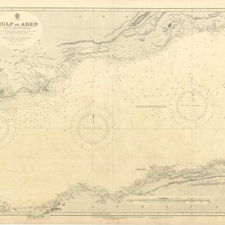
Gulf of Aden [...] Eastern Portion Including Socotra Island. No. 6a.
Standard issue, 814 x 1006 mm. Scale 1:712,000.
€ 400,00
Nautical chart of the Gulf of Aden including the Horn of Africa and Socotra Island, prepared by the British Admiralty. With three panoramic views featuring Ras Jard Hafún and its neighbouring hills.
The chart details the Arabian and African coasts, Abd al-Kuri, and the Socotra Islands. Among the major labeled places are Ras-al-Kalb, Mukalla, Shihr, and Ras Kusa'ir on the Arabian coast, as well as Ras Adado, Bandar Kassim, Alula, and Hafun on the African continent. The chart shows geological features, marking several limestone formations including Jebel Warsangeleh, and warns mariners of the somewhat outdated rendering of Cape Guardafui, and of approaching the eastern point of Socotra island during the south-west monsoon.
The British Admiralty has produced nautical charts since 1795 under the auspices of the United Kingdom Hydrographic Office (HO). Its main task was to provide the Royal Navy with navigational products and service, but since 1821 it has also sold charts to the public. The present chart was composed after surveys by the Indian navy as well as Admiralty surveys between 1836 and 1927; it was first published in 1886 and saw several corrections up to 1934.
Small marginal tear in the centrefold, pierced in one place. Slightly brownstained. Two folds. A few manuscript notes and stamp "Increase 50%" near lower right corner. Captioned in print and in a former collector's hand on verso.
![Indian Ocean - Northern Portion [Admiralty Chart No 748b].](https://inlibris.com/wp-content/uploads/2023/10/img-bn33603-324x324.jpg)
![Gulf of Aden [...] Eastern Portion Including Socotra Island. No. 6a.](https://inlibris.com/wp-content/uploads/2022/04/img-bn58797-324x324.jpg)