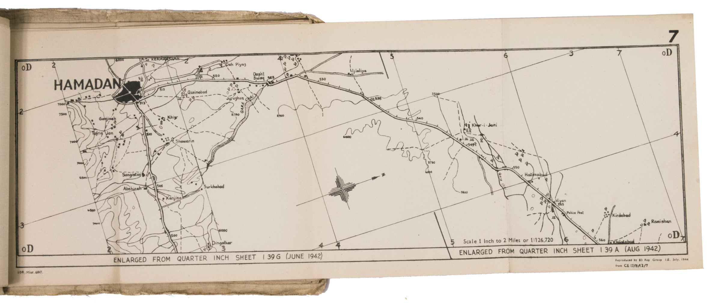
The only known copy of military road maps of the Persian corridor
Road strip maps Iran. Dizful-Kazvin (1-10), Hamadan-Khosrovi (11-16).
Oblong folio (210 × 255 mm). With 1 index map and 16 numbered folding strip maps. Original beige printed paper wrappers, side-stitched (by hand) through 3 holes with a pink cloth ribbon.
€ 3.500,00
Exceptionally rare collection of folded strip maps of roads in western Iran, very likely meant for military use during the Second World War. The inscription on the front wrapper possibly stands for "24th Brigade, branch transportation office", though it is unknown which 24th brigade this would have been. The maps were originally printed on quarter inch sheets in 1942 and have been significantly enlarged for this edition to a scale of 1 inch to 2 miles. We have not been able to trace any other copies of either the first or second edition of this work anywhere.
An owner's inscription on the front wrapper.
The maps and back wrapper have been reinforced with bookbinder's gauze. The wrappers are somewhat soiled, creased and the edges are somewhat frayed. The maps are slightly browned and the index map has a small, brown stain in the lower outer corner (not affecting the image). Otherwise in good condition.
Ähnlich
-

Reize naar Arabië en andere omliggende landen.Amsterdam & Utrecht, 1776-1780.
€ 6.000,00 -

Voyage en Arabie & en d'autres Pays circonvoisins. Tome premier (-second). …Amsterdam & Utrecht, 1775-1780.
€ 6.000,00 -
![La seconda [terza, quarta] parte delle relationi universali.](https://inlibris.com/wp-content/uploads/2020/05/img-bn44415-324x324.jpg)
La seconda [terza, quarta] parte delle relationi universali.Brescia, 1599.
€ 3.000,00 -
Travels to the City of the Caliphs, along the Shores of the Persian Gulf …London, 1840.
€ 6.000,00
