R.A.F. 1:500,000 / 1:1,000,000 aeronautical charts.
9 colour-printed maps, 567 x 737 mm. Scale: 1:500,000 and 1:1,000,000.
€ 4.500,00
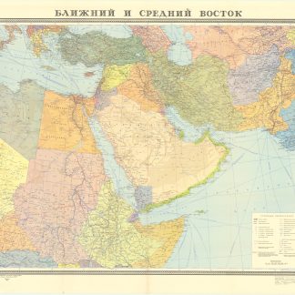
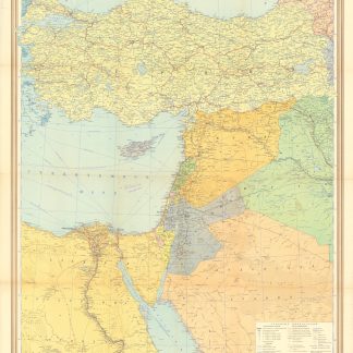
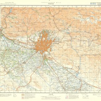
British military aeronautical charts of the borderlands between Saudi Arabia, Iraq and Jordan, along with portions of Syria, Lebanon, Egypt, Turkey and Cyprus - all including a disclaimer that they "must not be considered an authority on the delimitation of international boundaries".
The set comprises five first editions, the remaining maps either second or third editions: six maps of GSGS series 4715 depicting Al Azaq (446A), Tabuk (446D) and the Gulf of Aqaba (447C) next to Damascus (426C), Hamah (426B), Jerusalem (447B) and their surroundings. Further, two maps originating from GSGS series 4695 showing Wadi Sirhan (446) in Saudi Arabia and Lake Van (340) in Turkey; finally, one map from GSGS series 4622 displaying the coasts of Lebanon and Syria as well as Cyprus (2426).
Issued by the Geographical Section, General Staff (GSGS) that supplied maps to the British Armed Forces (in this case, the R.A.F.), collected data on foreign survey networks, and prepared survey data for Expeditionary Force mobilisation.
GSGS 4715: sheets 447B (first ed.), 426B (second ed.), 426C (first ed.), 446A (second ed.), 446D (second ed.), 447C (first ed.).
GSGS 4695, sheets 340 (third ed.), 446 (first ed.).
GSGS 4622, sheet 2426 (first ed.).
The maps of Lake Van and Cyprus have larger tears, affecting text and image. Small portion of the map of Aqaba torn away at the upper edge with some text loss. The remaining maps show occasional small marginal flaws.