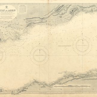
![Port Sudan [and] Approaches to Port Sudan. No. 3492.](https://inlibris.com/wp-content/uploads/2022/04/img-bn58781.jpg)
Port Sudan [and] Approaches to Port Sudan. No. 3492.
Standard issue, 700 x 1025 mm. Scale 1:10,000 and 1:25,000.
€ 350,00
Detailed nautical chart of Port Sudan, the primary port of Sudan, prepared by the British Admiralty. Undoubtedly one of the best maps of the young city, which was built between 1905 and 1909 by the administration of Anglo-Egyptian Sudan to replace Suakin. Both the city of Port Sudan as well as the approaches to Port Sudan are combined on a single sheet.
The chart details numerous mooring posts, the port police, cranes and the customs office, as well as dangerous coral reefs stretching across the entire shore of Port Sudan. It includes landmarks such as churches and mosques, the Governor's residence, the public garden, school, and hospital, as well as sports clubs and the Polo grounds. Another interesting detail is the pipeline from the West to the South Town as well as the Atbara and Port Sudan railway. In addition, the Approaches chart displays offshore features like the Wingate Reefs and the North Towartit Reef.
The British Admiralty has produced nautical charts since 1795 under the auspices of the United Kingdom Hydrographic Office (HO). Its main task was to provide the Royal Navy with navigational products and service, but since 1821 it has also sold charts to the public. The Port Sudan chart was composed after an Admiralty survey of 1904; the Approaches chart is the result of a 1927 survey carried out by HMS Endeavour. The entire chart was first published in 1929 and saw several corrections up to 1937.
With a single fold. Captioned in print and in a former collector's hand on verso.
![Gulf of Aden [...] Eastern Portion Including Socotra Island. No. 6a.](https://inlibris.com/wp-content/uploads/2022/04/img-bn58797-324x324.jpg)
![Port Sudan [and] Approaches to Port Sudan. No. 3492.](https://inlibris.com/wp-content/uploads/2022/04/img-bn58781-324x324.jpg)