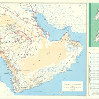
Saudi Arabian road map.
Large folding map (60 x 90.5 cm), printed in colour, depicting the Kingdom of Saudi Arabia and its main roads. With the title in both Arabic and English and a table with the distances from one city to another. Printed on two sides, one side with the map in English and the other in Arabic.
€ 1.000,00
Bilingual road map of the Arabian Peninsula for Aramco employees. Focusing on Saudi Arabia, the map shows the main roads as well as surfaced roads, trails, roads under construction and even proposed roads. A list titled "hints for survival" mentions straightforward traffic rules such as "come to a complete stop at stop signs and observe stop-and-go signals" and "observe speed laws in the community where you live as well as on the highway". The headline makes readers fear the worst for Saudi Arabian traffic of this period. The Arabic side of the map contains the same "hints" as well as a list of road signs in Arabic and English. A table lists the distance in kilometres from several towns and cities to some of the major cities: Buraidah, Dhahran, Dammam, Hofuf, Jeddah, Mecca, Medina, Riyadh and Ta'if.
In very good condition.
Ähnlich
-
Travels to the City of the Caliphs, along the Shores of the Persian Gulf …London, 1840.
€ 6.000,00 -

A Series of Adventures in the Course of a Voyage up the Red-Sea, on the …London, 1780.
€ 12.500,00 -

Carte de l’Empire Ottoman comprenant les possessions de la Porte en Europe, …Paris, 1825.
€ 3.000,00 -

Reize naar Arabië en andere omliggende landen.Amsterdam & Utrecht, 1776-1780.
€ 6.000,00