![Ha-Levanon: tsiyure masa. [Lebanon: Travel Sketches].](https://inlibris.com/wp-content/uploads/2023/02/img-bn61116.jpg)
![Ha-Levanon: tsiyure masa. [Lebanon: Travel Sketches]. – Bild 2](https://inlibris.com/wp-content/uploads/2023/02/img-bn61116-a.jpg)
![Ha-Levanon: tsiyure masa. [Lebanon: Travel Sketches]. – Bild 3](https://inlibris.com/wp-content/uploads/2023/02/img-bn61116-b.jpg)
Lebanon in the 1920s: with map and photos
Ha-Levanon: tsiyure masa. [Lebanon: Travel Sketches].
Tel-Aviv, 1930.
Small 4to (125 x 175 mm). 67, (5) pp. Original printed wrappers.
€ 350,00
A description of travels throughout Lebanon, written in Hebrew and including a map of the region labeled in Hebrew as well as numerous half-tone illustrations from photographs. Rafael Sverdlov (b. 1885) was a geography teacher at schools in Tel Aviv, and as both resident and teacher had both a personal and professional understanding of the landscapes of the area. The in-text illustrations show Roman-era ruins, rivers, and tree plantations.
A touch of wear, otherwise quite well preserved.
Literatur
OCLC 19179078.
Ähnlich
-
![Beschreibung der Reyß [...], so er [...] gegen Auffgang in die Morgenländer, fürnemlich Syriam, Judeam, Arabiam, Mesopotamiam, Babyloniam, Assyriam, Armeniam, etc. nicht ohne Mühe und grosse Gefahr selbst vollbracht [...].](https://inlibris.com/wp-content/uploads/2020/05/img-bn44592-324x324.jpg)
Beschreibung der Reyß [...], so er [...] gegen Auffgang in die Morgenländer, …Frankfurt a. M., 1582.
€ 8.500,00 -
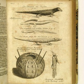
Reisen oder Anmerkungen verschiedene Theile der Barbarey und der Levante …Leipzig, 1765.
€ 2.000,00 -

The complete series of the first 200 works issued by the Hakluyt Society.London, 1847-1958.
€ 165.000,00 -
Reizen van Cornelis de Bruyn, door de vermaardste deelen van Klein Asia, …Delft, 1698.
€ 25.000,00
![Ha-Levanon: tsiyure masa. [Lebanon: Travel Sketches].](https://inlibris.com/wp-content/uploads/2023/02/img-bn61116-324x324.jpg)