
American map of Middle Eastern oil
[WWII map of oil fields in Egypt, the Arabian Peninsula, and West Asia].
Black and white map on newspaper, 240 x 275 mm and mounted on a sheet of paper, 270 x 380 mm.
€ 1.500,00
A fascinating wartime map of oil fields and supply lines in the midst of the Second World War, highlighting the vast importance of the Arabian Peninsula, Egypt, and West Asia for the Allied war effort, which required an immense and constant supply of petrol.
Vying for oil was a constant concern for both the Axis powers and the Allies throughout the war, and one which informed military strategy. Clearly printed in the midst of the Nazi invasion of Russia, with the areas controlled by the Axis powers and the U.S.S.R. accurate for September of 1941, the map is an informative snapshot of the tense mid-war years, with helpful comments hovering over relevant sections: "Oil concession in Saudi Arabia held by Americans", "U.S. aid to Russia goes over new Iranian railway", "Largest single oil field in world" over Abadan, and "German-Italian nationals not permitted in Afghanistan". Axis bases are marked with a swastika, and Allied ones with a four-pointed star. Railroads, pipelines, and shipping lanes are given particular attention.
A stylistically similar map printed on the reverse of the oil map, covered by the backing paper but still visible if held to light, can be identified as a graphic titled "Where Continents at War Come Closest" (focusing on the Arctic Circle), which ran on page 48 in a February 14, 1942 edition of an American newspaper named The Escanaba Daily Press in Michigan; four days later it ran on page 23 of The Rhinelander Daily News in Wisconsin. Likely these maps and their accompanying article ran in many American newspapers in early 1942. Certainly the map itself mentions American interests twice, perhaps hoping to convince the American public of the importance of the Muslim world in the war effort (and regarding American economic interests, pertaining to oil concessions and the dissemination of U.S. aid).
Haifa has been marked on the map in pencil, and another illegible note in ink appears to mark Ashdod, which today is second only to Haifa in oil refining in Israel, though its refinery was not constructed until the 1970s.
Toned, with two closed tears rebacked by mounting paper; mounting mapper chipped, altogether in good condition.
Ähnlich
-
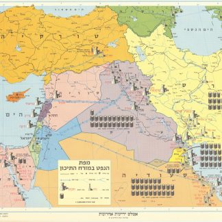
Mapah ha-neft ba-mizrah ha-tikhon (Map of the Oil Industry in the Middle …Jerusalem, 1963.
€ 2.500,00 -
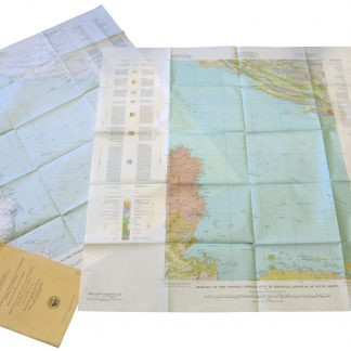
Geographic Map of the Central Persian Gulf Quadrangle Kingdom of Saudi …Washington, D.C., 1959-1961 CE = 1378-1380 H.
€ 9.500,00 -
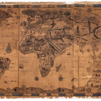
Lithographed facsimile of the world map painted on vellum for Henry II, …Paris, 1852.
€ 250.000,00 -
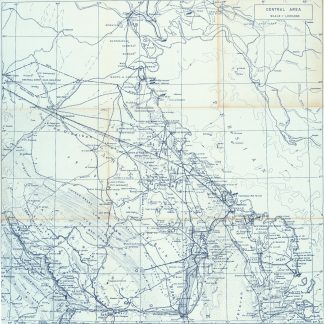
Central Area. Scale 1:1,000,000.Dhahran, 1953 or shortly after.
€ 6.500,00
