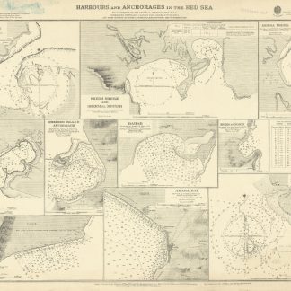
Harbours and Anchorages in the Red Sea. No. 3047.
Standard issue 516 x 688 mm. Scales 1:7,230 to 1:29,040.
€ 1.500,00
Nautical chart of ten of the principal harbours and anchorages of the Red Sea, prepared by the British Admiralty: Sherm Sheikh, Sherm el Moiyah, Mersa Diba, Sherm Habban, Omeider Island, Dahab, Sherm en Noman, Wasit anchorage, Akaba Bay, and Khor el Wahla. The chart of Akaba Bay shows Akaba City and the ruined fort as well as Victoria Pier and an observation spot. Several charts show dangerous coral reefs, including Harrier reef on the Khor el Wahla chart.
The British Admiralty has produced nautical charts since 1795 under the auspices of the United Kingdom Hydrographic Office (HO). Its main task was to provide the Royal Navy with navigational products and service, but since 1821 it has also sold charts to the public. The present chart was composed after surveys by the Austrian Imperial ship "Pola" in 1895-96, as well as an admiralty survey of 1918; it was first published in 1899 and saw several corrections up to 1921.
With a stamp "Increase 50%" near upper margin. Captioned in former collectors' hands on verso. Blueish smudge near upper margin; several small marginal tears, only one of which touching text.
Ähnlich
-

Arabia with the adjacent Countries of Egypt & Nubia.Edinburgh, 1828.
€ 750,00 -
A Collection of Voyages and Travels, Some Now First Printed from Original …London, 1744-1746.
€ 35.000,00 -

Descriptio orbis antiqui in XLIV tabulis exhibita.Nuremberg, ca. 1720.
€ 3.800,00 -
Första Resa fran Cairo till Arabiska Öknen i April 1845. Fragment.Helsingfors Helsinki, 1853.
€ 9.500,00