


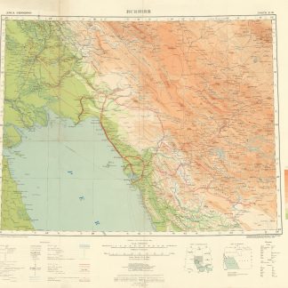
Kuwait. Series K961. Edition 5-NIMA, Al-Ahmadi.
Colour-printed map in 2 sheets, 2110 x 1665 mm. Scale 1:12,500.
€ 3.000,00
Classified map of Kuwait, prepared for military use by the U.S. National Imagery and Mapping Agency; marked "for official use only". An incredibly detailed city plan of Al Ahmadi and its sourroundings in southern Kuwait, home of the headquarters of Kuwait National Petroleum Company (KNPC) and Kuwait Oil Company (KOC), with many of its refineries located there. Indeed, the present map indicates various industrial facilities including gas and oil separation plants, oil refinieries and tank farms, as well as Kuwait Oil's main office and the Oil Workers' Union building. Since Al Ahmadi is not a key site for military presence, it is not surprising that the only military establishment indicated on the present map is an abandoned defence site featuring an airstrip marked "unusable", located between the city centre and Al Burqan oil field next to a similarly abandoned racetrack. The map further details the then less-developed coastal area east of Ahmadi city centre, showing Al Fintas, Sabahiya, Mangaf and al Hulayfah neighbourhoods as well as the "Ad Dahr housing project", government buildings, schools, hospitals, banks, markets, sports complexes, and other places of interest.
In excellent condition.
Ähnlich
-
Asia 1:1,000,000. Bushire. Sheet North H-39.London, 1918.
€ 950,00 -

Southwestern Asia, Series K502.Washington DC, 1956-1961.
€ 3.500,00 -

Saudi Arabia City Graphic. Ra's Tannurah. Series K9611. Edition 1-DMA.U.S. Government, 1994.
€ 1.500,00 -

Joint Operations Graphic. Series 1501 Air.London, 1991, 1998 and 2001.
€ 3.500,00
