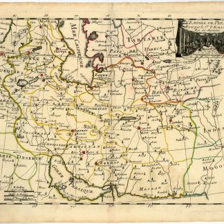
L'Empire de Perse.
220 x 285 mm. Engraved map in original hand colour.
€ 350.00
Detailed map of the Persian Empire, from Tartaria and the Caspian Sea to the Indian Ocean and the Gulf. Essentially a map of modern Iran including Afghanistan, Azerbaijan and part of Georgia, but including portions of Turkey, Saudi Arabia and the Emirates. With Ras al-Khaima labelled ("Julfar"), conjoined with a remark on pearl fishing: "Icy les Perses pechent des Perles". In addition, the map shows an extensive network of caravan routes, not failing to indicate major towns such as Isphahan, Shiraz, Tiflis and Medina, along with landmarks like the ruins of Persepolis.
Originating from Le Rouge's "Atlas Nouveau Portatif [...] Introduction à la Géographie", published in Paris in 1748. George-Louis Le Rouge (1712-90), while known for his work in Paris, was originally born Georg Ludwig of Hanover, Germany. He grew up and was educated in Hanover, after which he became a surveyor and military engineer. Around 1740 Le Rouge moved to Paris and set up shop as an engraver and publisher. Le Rouge spent much of his forty-year career translating various works from English to French, and his cartographic influence often came from English maps. His experience as a surveyor and engineer in Germany made him a skilled and prolific cartographer, and he produced thousands of charts, maps, atlases, and plans, including the Franklin/Folger chart of the Gulf Stream, on which he worked with Benjamin Franklin.
Centrefold reinforced on the verso. A few small marginal tears, otherwise very well preserved.
Not in Al Ankary or Tibbetts.
Related
-

Reize naar Arabië en andere omliggende landen.Amsterdam & Utrecht, 1776-1780.
€ 6,000.00 -

Voyage en Arabie & en d'autres Pays circonvoisins. Tome premier (-second). …Amsterdam & Utrecht, 1775-1780.
€ 6,000.00 -

Carte de l’Empire Ottoman comprenant les possessions de la Porte en Europe, …Paris, 1825.
€ 3,000.00 -
Vierzig-Jährige Reise-Beschreibung. Worinnen dessen durch Türkey, Persien, …Nuremberg, 1681.
€ 8,500.00