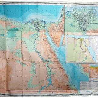
Ob'yedinennaya Arabskaya Respublika [United Arab Republic].
690 x 850 mm. Original colour-printed folding map. Scale 1:2,000,000. Folded and mounted in original printed paper boards, tall 8vo. With a 20 pp. index, loosely inserted.
€ 1,500.00
Second edition of this rare Russian topographic map of Egypt, or the United Arab Republic, as it would continue to style itself until 1971. Compiled and designed by the Scientific Editorial Cartographic Department of the Chief Directorate of Geodesy and Cartography (GUGK) of the Soviet Union. The map indicates the demarcation line of the 1949 Armstice Agreements and notes that "the borders of the State of Israel are shown in accordance with the resolution of the UN General Assembly dated 29 November 1947". Aside from towns and settlements, roads, railroads, pipelines, and ports, it details coral reefs, lava fields, permanent and moving sands, pyramids, and ruins. With inset maps of the Nile delta (scale 1:1,000,000), an economic map (scale 1:6,000,000), and a chart of annual rainfall and temperatures in the area. The accompanying explanatory booklet comprises a discussion of the country, along with an index of place names found on the map.
Edges of the cover slightly worn. Map and index in excellent condition.
OCLC 181134221, 1121431917.
Related
-

Voyage en Arabie & en d'autres Pays circonvoisins. Tome premier (-second). …Amsterdam & Utrecht, 1775-1780.
€ 6,000.00 -
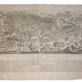
Gran Cairo.Bologna, 1670.
€ 20,000.00 -
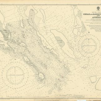
Red Sea - Gulf of Suez. Gimsah and Kabreit Anchorages and Approaches surveyed …London, 1920.
€ 800.00 -

Reisen oder Anmerkungen verschiedene Theile der Barbarey und der Levante …Leipzig, 1765.
€ 2,000.00