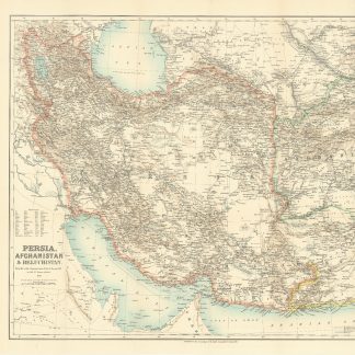
Persia, Afghanistan, Beluchistan and the Gulf
Persia, Afghanistan & Beluchistan. Compiled under the supervision of Hon. G. Curzon, M.P.
Original colour-printed map. 49 x 62 cm, on sheet 56 x 68 cm. Scale 1:3,810,000. 60 miles to an inch.
€ 450.00
Extremely detailed early mapping of Persia, Afghanistan, Beluchistan, and the Gulf, focusing on the physical geography, settlements, roads, railways, telegraph lines and other features of this geopolitically vital area. The future United Arab Emirates are still labelled the "Pirate Coast", with Abu Dhabi, "Debai", "Sharkah", and several other cities named. Qatar is called "El Katr", an early use of this name, with cities El Bidaa, Ras Laffan, Ras Rekkan, and Zabara named. Also, "Koweit" is named and located.
The map title credits George Curzon, one of the most important British statesmen of the late 19th and early 20th centuries, as the supervisor of the production of the map, with William John Turner, Fellow of the Royal Geographical Society, as the mapmaker. Around 1890 Turner partnered with W. Shawe to found "Turner & Shawe", a lithograph company working for the Royal Geographical Society. The present map bears the "Turner & Shawe" imprint in the lower right corner. The map was later reproduced by the Intelligence Division, War Office, under the direction of Lieutenant Colonel C. J. Dalton and appeared as a foldout in the 1900 confidential "Report on the Persian Army" by H. P. Picot.
A few small marginal tears. A fine copy.
OCLC 182541176.
Related
-

Carte de l’Empire Ottoman comprenant les possessions de la Porte en Europe, …Paris, 1825.
€ 3,000.00 -

Persian Gulf. ONC-H-6/7. Operational navigation chart.St. Louis, 1967.
€ 1,500.00 -
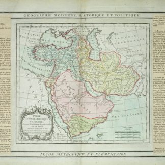
Perse, Turquie Asiatique et Arabie.Paris, 1799.
€ 450.00 -

Reize naar Arabië en andere omliggende landen.Amsterdam & Utrecht, 1776-1780.
€ 6,000.00