The first detailed survey of the birthplace of the ruling family of Abu Dhabi
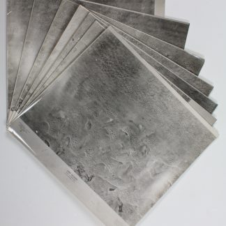
Aerial survey photographs (nos. 1-7). Liwa Villages.
7 black and white vertical aerial photographs, 240 x 265 mm. Scale 1:20,000. Stored in custom-made black card portfolio.
€ 18,000.00
A complete set of the first aerial survey of the Liwa Villages in the United Arab Emirates, published by Hunting Surveys Ltd but unrecorded in institutions. The seven photographs form a mosaic depicting a long stretch of the traditional homeland of the ruling Al Nahyan family of Abu Dhabi, with the E90 roadway - which today runs along the border with Saudi Arabia - visible winding through the dunes and oases in an area which is identifiable as Mzeer'ah and Al Liwa. This area is of particular importance not only as the original territory of the Al Nahyan family, but also as an oasis and more recently a tourist attraction and location for film sets, and as a border region with Saudi Arabia. Photographed in 1976-77, the first signs of infrastructure development are visible.
Hunting Surveys, which also operated as Hunting Geology and Geophysics, produced many early aerial views of the UAE, with their mid-1970s work recording the earliest years of the Union during a time when mapping via aerial photography was a vitally important task, with relevance for geological studies, natural resource prospecting, and border disputes with Oman and Saudi Arabia. Not on NCAP, which lacks any UAE photos from the crucial years of the 1970s.
A touch of light wear; in good condition.
Related
-
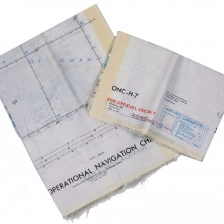
Persian Gulf. ONC-H-6/7. Operational navigation chart.St. Louis, 1969.
€ 2,800.00 -

Voyage en Arabie & en d'autres Pays circonvoisins. Tome premier (-second). …Amsterdam & Utrecht, 1775-1780.
€ 6,000.00 -

Carte de l’Empire Ottoman comprenant les possessions de la Porte en Europe, …Paris, 1825.
€ 3,000.00 -
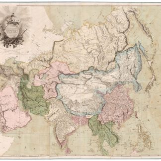
Asia. To Major James Rennell, Esqr. F.R.S. &c. &c. This Map is …London, 1801.
€ 12,500.00