

Royal Air Force presence on the Gulf
Habbaniya - Shaibah, Strip No. 12 & Shaibah - Bahrein, Strip No. 13.
2 original photolithographed maps. Ca. 305 x 895 mm and 303 x 915 mm. Scale 1:1,000,000. Backed on linen.
€ 1,500.00
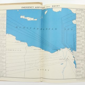
Rare military maps of Iraq and the Gulf, detailing an area of about 650 statute miles between three Royal Air Force bases: from Habbaniya in the north, about 89 km west of Baghdad, over Shaibah in the Basrah Governorate, all the way to Muharraq (Bahrain) in the south. Of these three stations, RAF Habbaniya was the largest and most important, operating from October 1936 until May 1959. Apart from the airfield it included the Air Headquarters of RAF Iraq Command, communication facilities, maintenance units, an aircraft depot, an RAF hospital, RAF Iraq Levies barracks, the RAF Armoured Car Company depot as well as fuel and bomb stores.
The maps label further military bases such as Jubail, Ras Tanura, Dhahran and Doha, along with the Iran, Kuwait and neutral zone borders. Extremely detailed, both charts show the Mesopotamian Marshes, giving an idea of the wetlands' vast expanse before they were drained from the 1950s onwards.
Somewhat duststained; some small marginal tears.
Related
-
Voyage de la côte de Malabar à Constantinople, par le Golfe Persique, …Paris, 1820.
€ 7,500.00 -
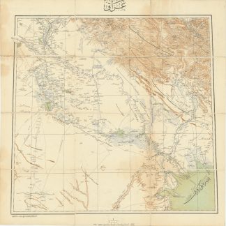
Iraq.Istanbul, 1915 CE = 1331 Rumi.
€ 3,500.00 -

(The Travels of Peter Teixeira from India to Italy by Land.) A View of …London, 1710.
€ 4,500.00 -
Air Route books for pilots flying from Cairo to Karachi. Navigation Branch …No place, 1944.
€ 3,500.00
