The early days of modern Ras Al Khaimah
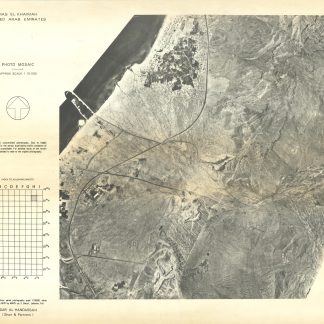
Ras Al Khaimah. United Arab Emirates.
3 sheets, with black and white photographic prints. 690 x 570 mm. Scale 1:10,000.
€ 3,500.00
Photographed just four years after the formation of the UAE: three aerial photographs of the port and city of Ras Al Khaimah as it was in the early days of the union. Much of the views are dedicated to the natural and man-made harbours, islands, and wetlands which first lent Ras Al Khaimah its status as a port city. Of particular interest is the snapshot of early industrial developments, like highways and man-made harbours, and a glimpse at the shoreline before it was modernized through dredging projects.
The aerial photographs were taken by a Lebanese company, MAPS sarl, today still operational under the name Maps Geo. While many other early aerial surveys of the UAE were undertaken by companies from further afield (like Hunting, based out of Britain), MAPS was founded in and photographed the Middle East.
Sheets rolled for storage; in excellent condition.