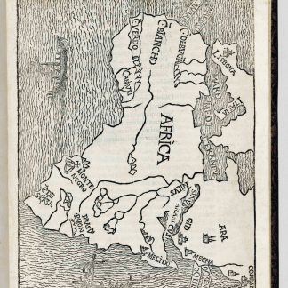
The first known printed reference to the Arabian Gulf region, with the earliest map to call the Gulf “Sinus Arabicus” instead of “Sinus Persicus”
Itinerarium Portugallensium e Lusitania in Indiam et inde in occidentem et demum ad Aquilonem.
Small folio (184 x 266 mm). (10), LXXVIII pp. Title-page with woodcut map of Africa, Arabia and southern Europe and India (second issue, with "Sinus P[er]sicus" changed to "Sinus Arabicus"). 19th century green morocco, sides with triple-fillets surrounding the central arms of The Signet Society. Spine gilt-lettered and gilt-tooled, edges gilt. Stored in green quarter morocco folding case.
€ 550,000.00
First Latin edition of the most important and "earliest printed collection of voyages and discoveries" (PMM), containing the reports of the voyages of Columbus, Vespucci, Cabral (Brazil), Cadamos (Africa) and, perhaps most importantly, "the earliest printed account of the voyage of Vasco da Gama" to India (PMM). This voyage to the eastern hemisphere is comparable in importance only to Columbus's in the west, as it "opened the way for the maritime invasion of the East by Europe" (PMM). "After Columbus' letters the most important contribution to the early history of American discovery" (Sabin). It is also the only edition to include the map, which is one of the first non-Ptolemaic maps to include Arabia and the earliest "modern" printed map to show Mecca. The present copy contains the rare Index, which ”was apparently printed after the publication of the work, and inserted into the few available copies, so that today it is almost invariably missing” (Jones, Adventures in Americana).
"It is evident by the contents, and as Rodrigues observes, everything in this book is of great importance: 'accounts of the two voyages are published for the first time of Cadomoto to Cape Verde and Senegal in the service of Portugal; it was the first time that the narratives were published of the of the voyage of Vasco da Gama, and that of Pedro Alvares Cabral to India and Brazil; it was also the first time that Amerigo Vespucci's third voyage, of great interest to Brazil, was printed in Italian; it was the first time that curious documents written by the Venetian officials in Lisbon, some of which refer specifically to Brazil, and comprising Book VI, were printed. And apart from all this, the first three voyages of Columbus, that of Alonzo Niño, and that of Pinzón appear here in their second edition. This book is not a jewel, it is a cluster of jewels'. It is obviously a work of the greatest interest for Brazilians" (Borba de Moraes).
The map on the title-page, not included in the original 1507 Italian edition or any subsequent edition, is the earliest to show Africa completely surrounded by seas and, as one of the first non-Ptolemaic maps to include Arabia, definitely the earliest "modern" printed map to show Mecca. Published in 1508, it merged the Gulf with the Red Sea, so that it shows no water between "Mecha" (Mecca) and "Comban" (Cambay in India) except for the Indus River. It calls this amalgamated body of water the Gulf, but raises a controversy still with us more than 500 years later, for in the first state of the block it was called the "Persian Gulf" ("Sinus Persicus"), but the woodblock was revised with a patch to rename it the "Arabian Gulf" ("Sinus Arabicus"). The map therefore exists in two different states in copies of this edition. Ours is the rarer second one, with "Sinus Arabicus". Persia controlled the north coast of the Gulf at this time and early information about the region may have come from traders there, but the growing Portuguese presence, documented in the present book, may have led to the realization that the inhabitants were Arabic-speaking, not Persian-speaking. It is considered a "vehicle for the dissemination throughout Renaissance Europe of the news of the great discoveries both in the east and the west" (PMM).
Da Gama's pioneering sea voyage ranks amongst the greatest historic events of the second millennium and as "one of the defining moments in the history of exploration" (BBC History, online). It is also considered the turning point in the political history of the Arabian Gulf region, followed as it was by a prolonged period of east-west commerce, conquest and conflict. For better or worse, the discovery of the first all-water trade route between Europe and India catalysed a series of events that forever changed the political history and geography of the world. Portugal was the first European power to take an active interest in the Gulf region: "Vasco da Gama made the first known reference to this area when he travelled through the Strait of Hormuz to the sheikhdom of Julfar" (Romano). In Julfar, today known as Ras al-Khaimah and part of the United Arab Emirates, Da Gama made contact with the Islamic navigator Ahmed ibn Majid, still remembered as the "first Arabic seaman". On the basis of Portuguese and Arabic records, it has now been established that it was Ibn Majid who finally piloted Vasco da Gama's ship to India using an Arabian map then unknown to European sailors, who previously had been unable to cross the Arabian sea. By gaining trading access to Arabia and India, the Portuguese seized control of the whole region within a few years after Da Gama's discovery and were to dominate the Gulf area for centuries: "In less than two decades, Portuguese forces occupied Julfar and controlled the lower Gulf region. Eventually, the Portuguese extended their presence as far north as the island nation of Bahrein" (Romano).
First printed in Italian in Vicenza in 1507 as "Paesi novamente retrovati", the work was translated into Latin by the Milanese monk Archangelo Madrignano and printed the following year. In addition to the accounts of the exploration in the Americas, it contains important accounts of voyages in the Eastern Hemisphere. The book was published in the 16th century in several editions. The most important voyages are the first three voyages of Columbus, 1492-1500; the third voyage of Vespucci, 1501-02 (to Brazil); Pedro Alvares Cabral's discovery of the Brazilian, Guianaian and Venezuelan coasts in 1500-01; Alvise da Cadamosto's explorations along the West African coast in 1456, which appears here for the first time; Vasco da Gama's explorations of Africa and India in 1497-99, and many others.
From the library of the Society of Writers to the Signet, the oldest legal society in the world (binding).
Title and woodcut map inlaid, with one letter on verso retouched in ink.
Borba de Moraes I, 580. Harrisse 58. Church 27. Edit 16, CNCE 39942. Alden/Landis 508/4. Brunet III, 474. Fumagalli 985. Hattendorf, The Boundless Deep, p. 111. Streeter, Americana Beginnings 3. Cf. PMM 42. A. Romano, A Historical Atlas of the United Arab Emirates, New York 2004, 26. Sabin 50058 ("of excessive rarity").
Related
-

Voyage en Arabie & en d'autres Pays circonvoisins. Tome premier (-second). …Amsterdam & Utrecht, 1775-1780.
€ 6,000.00 -
A Visit to the Wahabee Capital, Central Arabia. In: The Journal of the …London, 1865.
€ 3,500.00 -
La geografia di Claudio Tolomeo Alessandrino, nuovamente tradotta di Greco …Venice, 1561.
€ 25,000.00 -
The Navigation and v[o]yages of Lewes Vertomannus, Gentelman of the citie …London, 1577.
€ 265,000.00