![Diporti notturni. Dialloghi familliari [...] con la dimostratione figurale intagliata da Michel'Angelo Marrelli anconitano 1579.](https://inlibris.com/wp-content/uploads/2020/05/img-bn51121.jpg)
![Diporti notturni. Dialloghi familliari [...] con la dimostratione figurale intagliata da Michel'Angelo Marrelli anconitano 1579. - Image 2](https://inlibris.com/wp-content/uploads/2020/05/img-bn51121-a.jpg)
![Diporti notturni. Dialloghi familliari [...] con la dimostratione figurale intagliata da Michel'Angelo Marrelli anconitano 1579. - Image 3](https://inlibris.com/wp-content/uploads/2020/05/img-bn51121-b.jpg)
With the famous maps of the Mediterranean
Diporti notturni. Dialloghi familliari [...] con la dimostratione figurale intagliata da Michel'Angelo Marrelli anconitano 1579.
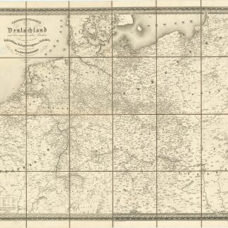
8vo (2 [instead of 14], 180 [instead of 188], (16) pp. With engraved title-page and 1 [instead of 3] double-page battle formation, 28 full-page maps and 2 full-page engravings by Michelangelo Marelli, all within the pagination. Woodcut printer's device on colophon leaf at end. 19th century half vellum over marbled boards.
€ 6,500.00
First edition; rare.
An NCO's pocket-sized manual containing general scientific and military information on architecture, geography, mathematics, duelling, drill, etc. The maps, which are the most famous of the book's illustrations, are almost exclusively of Mediterranean islands (with captions and sea monsters), particularly in the Aegean (cf. Zacharakis/Scutari 1499/1003-1518-1022), and include Rhodes, Crete, Cyprus, Malta (Ganado 1985, p. 231; not in MoM), Sicily (Dufour/L. 85), Elba, Corsica, Sardinia (not in Piloni), and Mallorca. The final map is of Great Britain (Shirley 124).
Occasional browning and waterstaining, lacking 6 leaves of preliminaries and pp. 29-36 (gatherings chi2 and ²chi2), including 2 battle plans. Slight loss to title, surviving battle plan slightly trimmed. Binding rubbed, showing minor staining.
Provenance: Faded contemporary Italian inscription on title ("Ex libris Joachimi Sabatini"?). Later in the collection of Thomas Fremantle, 3rd Baron Cottesloe (1862-1956), commander of the Territorial Army and president of the Society for Army History Research (purchased from Sotheran's, December 1936).
Edit 16, CNCE 18852. Brunet II, 1235. Olschki 4539. Cockle 548. Mortimer 184. Ayala 25. NMM III, pt. 1, no.38. Shirley T.FRRR-1a. OCLC 954791711. Not in Atabey or Blackmer.
Related
-
![Primera parte (Libro tercero y secundo volumen dela primera parte / Segunda parte y libro septimo) de la descripcion general de Affrica, con todos los successos de guerras que a avido entro los infieles, y el pueblo Christiano, y entre ellos mesmos desde que Mahoma inve[n]to su secta, hasta el año del señor mil y quinientos y setenta y uno.](https://inlibris.com/wp-content/uploads/2020/07/img-bn52893-324x324.jpg)
Primera parte (Libro tercero y secundo volumen dela primera parte / Segunda …Granada & Malaga, 1573-1599.
€ 28,000.00 -
![La seconda [terza, quarta] parte delle relationi universali.](https://inlibris.com/wp-content/uploads/2020/05/img-bn44415-324x324.jpg)
La seconda [terza, quarta] parte delle relationi universali.Brescia, 1599.
€ 3,000.00 -
Uebersichts-Karte aller in Deutschland und den angrenzenden Ländern seit …Berlin, 1830.
€ 400.00 -

Epistola potentissimi ac invictissimi Emanuelis Regis Portugaliae & …Vienna, 16 Sep 1513.
€ 45,000.00
![Diporti notturni. Dialloghi familliari [...] con la dimostratione figurale intagliata da Michel'Angelo Marrelli anconitano 1579.](https://inlibris.com/wp-content/uploads/2020/05/img-bn51121-324x324.jpg)