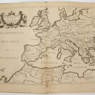
![Seetzens Entwurf einer Original Charte von Dschebal (Gebalene) und Scharah- (Seir-) Gebirge. Nach mündlichen Nachrichten [...] mit Hinzufügung der alten Namen von Fr. Kruse.](https://inlibris.com/wp-content/uploads/2021/10/img-bn52485.jpg)
Scarce lithographed map of southern Palestine
Seetzens Entwurf einer Original Charte von Dschebal (Gebalene) und Scharah- (Seir-) Gebirge. Nach mündlichen Nachrichten [...] mit Hinzufügung der alten Namen von Fr. Kruse.
Lithographed map, single sheet. 455 x 560 mm (image size), 516 x 645 mm (sheet size).
€ 750.00
Scarce lithographed map of southern Palestine showing the travel route of the German orientalist Ulrich Jasper Seetzen (1767-1811), designating landmarks like Petra and Saint Catherine's Monastery on the Sinai Peninsula, as well as geological features. The main map shows Seetzen's itinerary from the Be'er Sheva area to its intersection with the Egyptian caravan road from Mecca to Cairo, flanked in the east by Al-Sharah mountains and the Gebalene region. An inset depicts the continuation of the route from there to Mount Sinai, while another contains a detailed plan of the mountain. Features comments on soil fertility as well as labels of notable settlements, mountains, streams, and wall remains encountered along the route.
Prepared by A. Bräunig, the map was issued as plate 3 in the fourth volume of Seetzen's posthumous travelogue series "Reisen durch Syrien, Palästina, Phönicien, die Transjordan-Länder, Arabia Petraea und Unter-Aegypten", published from 1855 to 1859.
Very well preserved.
OCLC 5061964.
Related
-
Voyage dans le Levant en 1817 et 1818.Paris, 1819.
€ 35,000.00 -
![Hodaeporicon Indiae Orientalis; Das ist: Warhafftige Beschreibung der ansehnlich lobwürdigen Reyß, welche der edel, gestreng und weiterfahrne Ritter, H. Ludwig di Barthema von Bononien aus Italia bürtig, in die Orientalische und Morgenländer, Syrien, beide Arabien, Persien und Indien, auch in Egypten und Ethyopien, zu Land und Wasser persönlich verrichtet [...].](https://inlibris.com/wp-content/uploads/2020/05/img-bn45427-324x324.jpg)
Hodaeporicon Indiae Orientalis; Das ist: Warhafftige Beschreibung der ansehnlich …Leipzig, 1608.
€ 28,000.00 -

Reize naar Arabië en andere omliggende landen.Amsterdam & Utrecht, 1776-1780.
€ 6,000.00 -
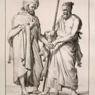
Antiquorum Patriarchatuum Descriptio.Paris, 1640.
€ 3,500.00
![Seetzens Entwurf einer Original Charte von Dschebal (Gebalene) und Scharah- (Seir-) Gebirge. Nach mündlichen Nachrichten [...] mit Hinzufügung der alten Namen von Fr. Kruse.](https://inlibris.com/wp-content/uploads/2021/10/img-bn52485-324x324.jpg)