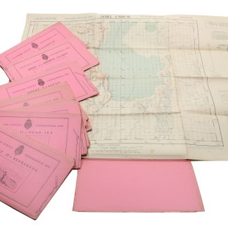
An important phase of the Survey of Palestine
Palestine Survey Maps.
490 x 725 mm. Various editions, 16 coloured sheets. Scale 1:100,000. Reliefs shown by contours, hachures and spot heights. Publisher's pictorial wrappers.
€ 6,500.00
Rarely found in such a complete group, these topographical maps document an important phase of the Survey of Palestine which was a direct result of the 1917 Balfour Declaration.
"The cadastral survey proceeded in fits and starts, through the Great Revolt of 1936-1939 and World War II. By the end of the mandate, the land was settled in less than 20 percent of Palestine, primarily in areas where Jewish colonies were established, such as the coastal plain, the Marj Ibn Amer valley, and north of Lake Tiberias by the Jordan River. The topographical maps were completed for all of Palestine, excluding the lower Negev. These were very valuable for military purposes during World War II" (Sitta).
Showing the district and sub-district boundaries, plus roads, notable buildings, police stations, minarets, in some cases Sheikh's tombs etc. The maps are as follows: 1. Metulla; 2. Haifa; 3. Safad; 4. Zikhron; 5. Nazareth; 6. Jaffa, Tel Aviv; 7. Nablus; 8. Yibna; 9. Ramle; 10 Jerusalem; 11. Gaza; 12. Hebron; 13. Dead Sea; 14. Rafah; 15. Beersheba; 16. Jebel Usdum.
A little edgewear and toning to wrappers; ownership inscription to each upper wrapper.
Sitta, Salman Abu, [review] "A Survey of Palestine under the British Mandate, 1920-1948", in: Journal of Palestine Studies 35.2 (Winter 2006), p. 102.
Related
-
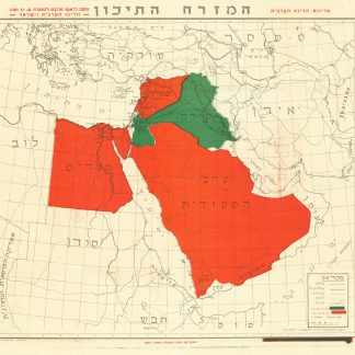
Ha’Mizrach Ha-Tichon (The Middle East) Ha’Liga Ha’Aravit (The Arab …Kfar Monash, 1949.
€ 2,800.00 -
![[Shanah be-Yisrael 708-709. Parashat ha-shanah bi-temunot]. A Year in Israel 5708-5709. A Pictorial Record.](https://inlibris.com/wp-content/uploads/2023/02/img-bn61132-324x324.jpg)
[Shanah be-Yisrael 708-709. Parashat ha-shanah bi-temunot]. A Year in Israel …Tel-Aviv, 1949 CE = 5709.
€ 450.00 -
![Mapat Medinat Yis´ra'el bama'arakha [Map of the State of Israel in the Campaign].](https://inlibris.com/wp-content/uploads/2023/03/img-bn61144-324x324.jpg)
Mapat Medinat Yis´ra'el bama'arakha [Map of the State of Israel in the …Tel Aviv, 1949.
€ 1,500.00 -
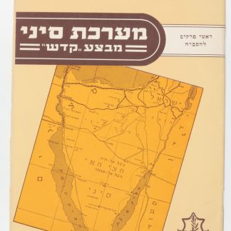
Ma’Rechet Sinai “Mivza Kadesh” (The Sinai War "Operation Kadesh").Tel Aviv, 1957.
€ 950.00