![Atlas der evangelischen Missions-Gesellschaft zu Basel. Nach den Angaben der Missionare Locher, Plessing, Kies, Albrecht, Weigle, Dr. Gundert, Lechler & Winnes [...].](https://inlibris.com/wp-content/uploads/2025/04/img-bn60588.jpg)
![Atlas der evangelischen Missions-Gesellschaft zu Basel. Nach den Angaben der Missionare Locher, Plessing, Kies, Albrecht, Weigle, Dr. Gundert, Lechler & Winnes [...]. - Image 2](https://inlibris.com/wp-content/uploads/2025/04/img-bn60588-g.jpg)
![Atlas der evangelischen Missions-Gesellschaft zu Basel. Nach den Angaben der Missionare Locher, Plessing, Kies, Albrecht, Weigle, Dr. Gundert, Lechler & Winnes [...]. - Image 3](https://inlibris.com/wp-content/uploads/2025/04/img-bn60588-h.jpg)
![Atlas der evangelischen Missions-Gesellschaft zu Basel. Nach den Angaben der Missionare Locher, Plessing, Kies, Albrecht, Weigle, Dr. Gundert, Lechler & Winnes [...]. - Image 4](https://inlibris.com/wp-content/uploads/2025/04/img-bn60588-b.jpg)
![Atlas der evangelischen Missions-Gesellschaft zu Basel. Nach den Angaben der Missionare Locher, Plessing, Kies, Albrecht, Weigle, Dr. Gundert, Lechler & Winnes [...]. - Image 5](https://inlibris.com/wp-content/uploads/2025/04/img-bn60588-d.jpg)
![Atlas der evangelischen Missions-Gesellschaft zu Basel. Nach den Angaben der Missionare Locher, Plessing, Kies, Albrecht, Weigle, Dr. Gundert, Lechler & Winnes [...]. - Image 6](https://inlibris.com/wp-content/uploads/2025/04/img-bn60588-e.jpg)
![Atlas der evangelischen Missions-Gesellschaft zu Basel. Nach den Angaben der Missionare Locher, Plessing, Kies, Albrecht, Weigle, Dr. Gundert, Lechler & Winnes [...]. - Image 7](https://inlibris.com/wp-content/uploads/2025/04/img-bn60588-f.jpg)
![Atlas der evangelischen Missions-Gesellschaft zu Basel. Nach den Angaben der Missionare Locher, Plessing, Kies, Albrecht, Weigle, Dr. Gundert, Lechler & Winnes [...]. - Image 8](https://inlibris.com/wp-content/uploads/2025/04/img-bn60588-a.jpg)
![Atlas der evangelischen Missions-Gesellschaft zu Basel. Nach den Angaben der Missionare Locher, Plessing, Kies, Albrecht, Weigle, Dr. Gundert, Lechler & Winnes [...]. - Image 9](https://inlibris.com/wp-content/uploads/2025/04/img-bn60588-c.jpg)
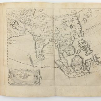
Atlas der evangelischen Missions-Gesellschaft zu Basel. Nach den Angaben der Missionare Locher, Plessing, Kies, Albrecht, Weigle, Dr. Gundert, Lechler & Winnes [...].
Oblong folio (272 x 370 mm). (12) pp. With 9 (instead of 11) lithographed maps. Marbled wrappers.
€ 950.00
Second edition. A protestant missionary atlas comprising 9 coloured lithograph maps indicating missionary stations across Africa and East Asia. Includes maps of Africa as a whole, the Gold Coast in particular, the entire Indian subcontinent, Canara, Malabar and the Nilgiri Mountains, as well as a general map of South-East Asia detailing China and Mongolia, Japan, Korea, Taiwan, Burma, Laos and present-day Thailand, concluding with a map showing Shenzhen, Hongkong and Macau. Enriched with a members' index of the Basel Mission as well as a directory of their missionary stations.
Lacks the world map and the map of Southern Maratha.
Occasional light foxing.
BM Archives J.116b. OCLC 34734567.
Related
-
Morgenländische Reyse-Beschreibung.Hamburg, 1658.
€ 11,000.00 -

Vierzig-Jährige Reise-Beschreibung. Worinnen dessen durch Türkey, Persien, …Nuremberg, 1681.
€ 8,500.00 -
![The First Booke of the Historie of the Discoverie and Conquest of the East Indias, Enterprised by the Portingales, in their Daungerous Navigations [...].](https://inlibris.com/wp-content/uploads/2021/08/img-bn56683-324x324.jpg)
The First Booke of the Historie of the Discoverie and Conquest of the East …London, 1582.
€ 85,000.00 -
![Memoir on Bahreyn. (And:) Pengelly, W. M. Remarks on a Portion of the Eastern Coast of Arabia between Muscat and Sohar. (In:) The Transactions of the Bombay Geographical Society. From June 1860 to December 1862. [...]. Volume XVI.](https://inlibris.com/wp-content/uploads/2024/04/img-bn63639-324x324.jpg)
Memoir on Bahreyn. (And:) Pengelly, W. M. Remarks on a Portion of the Eastern …Bombay, 1863.
€ 15,000.00
![Atlas der evangelischen Missions-Gesellschaft zu Basel. Nach den Angaben der Missionare Locher, Plessing, Kies, Albrecht, Weigle, Dr. Gundert, Lechler & Winnes [...].](https://inlibris.com/wp-content/uploads/2025/04/img-bn60588-324x324.jpg)