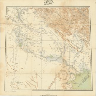
1917 map of Kuwait and the coastline of the Gulf
Mesopotamia. Sheet No. 2. Kuwait.
Heliozincograph map in colour (1050 x 731 mm). Folds to a booklet (185 x 130 mm). Scale 1:126,720.
€ 2,500.00
British map of Kuwait in the midst of WWI, just prior to the postwar political changes which would soon shift the landscape of the Gulf region. As part of a series on Mesopotamia, the map was published under the direction of Colonel Sir Sidney Gerald Burrard (1860-1943) during his tenure as Surveyor General of India. Burrard was famous for his cartographic work, especially for the application of his expertise when the Great Trigonometrical Survey ran into trouble mapping the Himalayas.
The map itself shows a long coastline of the Arabian Gulf and Kuwait in careful detail. Notes are made not merely of elevation, cities, and topography, but of interesting local details: on Failakah Island, a beach with a "good boat landing" is carefully noted, as are brackish wells and oases; a rough grid of the streets of Kuwait City shows the location of the "Shaikh's Palace", possibly the Seif Palace constructed under Moubarak Al-Sabah (1837-1915), judging by the location indicated on the map.
Small closed tear. Altogether, a handsome map and an interesting snapshot of Kuwait and the Gulf in 1917.