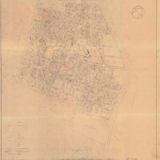
City planning in 1960s Kuwait
[City planning maps of Kuwait City and surroundings].
10 black-and-white electrostatic printed maps, ranging from 1050 x 910 mm to 585 x 465 mm.
€ 8,500.00
Likely a very small print run of city planning maps from 1960s to 1970s Kuwait, during the widespread development boom of the mid-20th century which saw Kuwait profit from the oil economy and undertake many modernization and expansion efforts. Maps include the development plans for a portion of the Ali Al Salem Air Base area, the base itself later partly destroyed during the Gulf War, a city block in Salmiya and Hawally, respectively, both with the Kuwait Technical Affairs Dept ink stamp to verso, and Kuwait City and several of its suburbs, including Al Khalidiya, Al Salam, and the Dasman Palace area, which also saw heavy fighting during the Gulf War.
Most charts show a detailed plan of single city block, but two give a wider view as well: one covers the entirety of Kuwait City as it was in 1961, street names labelled, with the older docks and lack of later extensions clearly visible. Another large map shows the Khalidiya district in full, with city blocks broken into individual buildings and a key labelled in both Arabic and English noting shops, schools, industrial areas, mosques, and even water pumps, playing fields, open spaces, and medical clinics.
Light wear, including some minor staining and tape repairs on the reverse of a few maps. Altogether an informative and detailed snapshot of Kuwait in the midst of development, and a good record of city planning and civil engineering in the capital region.
Related
-

Voyage en Arabie & en d'autres Pays circonvoisins. Tome premier (-second). …Amsterdam & Utrecht, 1775-1780.
€ 6,000.00 -
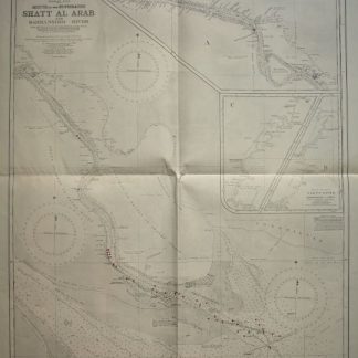
Persian Gulf. Mouth of the Euphrates. Shatt Al Arab and Bahmanshir River. …London, 1944.
€ 1,500.00 -
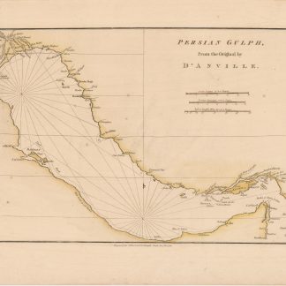
Persian Gulf. From the original by D'Anville.London, 1788.
€ 400.00 -

Carte de l’Empire Ottoman comprenant les possessions de la Porte en Europe, …Paris, 1825.
€ 3,000.00