Mid-19th century intelligence on the Trucial States: the original edition
Historical and other information, connected with the province of Oman, Muskat, Bahrein, and other places in the Persian Gulf. [Series title at head: Selections from the Records of the Bombay Government. No. XXIV - New Series].
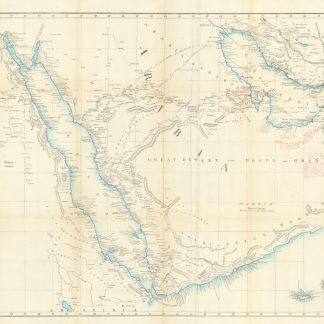
Large 8vo (182 x 270 mm). XXVII, (1), 687 pp., including 6 lithographed folding maps and plans (a very large, partly hand-coloured area "Map of Maritime Arabia", 930 x 586, inserted in lower-cover pouch; a "Sketch of Ras-ool Khymah"; a "Sketch of the Island of Kenn"; a "Plan of the Bassadore Roads"; a "Trigonometrical Plan of the Harbour of Grane or Koweit"; and a "Reduced Copy of Chart of the Gulf of Persia"), 1 printed folding table on p. 327f. ("Statement of the Number of Inhabitants, Vessels, Houses, and Date Trees of the Joasmee Ports in 1826, contrasted with the same in 1831"), and a hand-coloured text illustration ("flag of the friendly Arabs, White pierced Red", p. 76). Modern full green library cloth with title gilt to spine.
€ 150,000.00
First edition, of the utmost rarity, especially when complete with all the inserted maps and plans.
A trove of historical and topographical information on the Arabian Gulf region in the mid-19th century, under the British protectorate. Focusing on the area of the modern-day United Arab Emirates (then the "Trucial States"), Qatar, Bahrein, and Oman, the volume constitutes "a collection of reports received by the Government of Bombay and was designed to serve as a reference book for officers working in the area [...] Anyone working on the 19th century history of Eastern Arabia and the Gulf comes across frequent references to it [...] It served as a basic source for Lorimer in his Gazetteer of the Persian Gulf, Oman and Central Arabia. It contains, however, a great deal more information that Lorimer omitted, presumably for reasons of space. The history of Abu Dhabi which Lorimer dealt with in just over 4 pages here receives 34" (Bidwell). Illustrated with numerous strategically important maps and plans, the book contains a wealth of detail on the slave trade (including verbatim editions of treaties), on pearl fishing in "Al Bidder" (now Doha), on the local tribes, sailing directions for the coasts of the Sheikdoms, etc.
The period covered was key to the historical development to the region. From the early 19th century, the Wahhabist Qawasim’s operations on what the British referred to as the "Pirate Coast" had much hindered the use of the overland "Desert Mail" to communicate vital despatches to and from Britain’s burgeoning empire. General Keir's controversial punitive expedition to the Gulf in 1819 was a military success, resulting in the capture of Ras al-Khaimah and the other key Qawasim strongholds, and the ensuing General Treaty of Peace bound local sheikhs to abjure "plunder and piracy". "However, the British realised that the future security of the Gulf would depend less upon a piece of paper than upon the vigour with which they enforced it. A permanent presence would have to be maintained and to act as policemen both topographical and background knowledge have always been required: the papers printed in this volume were designed to provide this for the men on the spot and for their masters in Bombay" (Bidwell). Containing information of the greatest political and strategic relevance, the publication was intended for highly limited and selective distribution, as remarked by Bidwell: "Although the print run is not known, it must have been very small or much of it must have been lost. In the 17 years that I have been responsible for the library of the Middle East Centre at Cambridge, I have never known a copy offered for sale despite an assiduous watch on antiquarian booksellers and their catalogues". Since then, a single complete specimen is known to have appeared at auction (the Burrell copy, in 1999); two more, one formerly in the library of the British Agency at Muscat, were sold through us in 2014 and 2020, respectively.
Title-page a little brownstained; a few small edge tears professionally repaired. Numerous near-contemporary red ink annotations in neat hand, mainly pertaining to Oman, Arab tribes of the Gulf (especially the Qasimi), and "Piratical Maritime Resources and Population" on the Arabian coast, both to book and to the large map (slightly trimmed upon rebinding). Removed from the London Library with requisite de-accessioning stamps. A superbly preserved copy of this highly elusive, foundational text for the study of the Gulf in the modern era.
OCLC 34036809. Not in Macro. Cf. the 1985 Oleander Press reprint ("Arabian Gulf Intelligence"), with an introduction by Dr Robin Bidwell.
Related
-

Reize naar Arabië en andere omliggende landen.Amsterdam & Utrecht, 1776-1780.
€ 6,000.00 -
Österreichische Botschaftsberichte über arabische Länder. - Austrian …Wien Vienna, 1974.
€ 500.00 -

Persian Gulf. ONC-H-6/7. Operational navigation chart.St. Louis, 1967.
€ 1,500.00 -
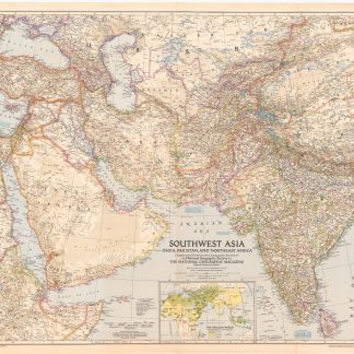
Southwest Asia, India, Pakistan, and Northeast Africa.Washington, DC, 1952.
€ 850.00