[Three articles on the development of the Hejaz Railway, in:] La Nature. Revue des sciences et de leurs applications aux arts et à l’industrie, journal hebdomadaire illustré (1905, 1910, 1913).
Large 8vo (200 x 290 mm). Pages 371f. (total volume: 422 pp.); pp. 263-269 (total volume: 426 pp.), p. 2 (total issue: 8 pp). In volumes 2, 24 and issue 2115 of the French weekly "La Nature". Contemporary half leather over marbled boards (1905) and original wrappers (1910, 1913).
€ 1,500.00
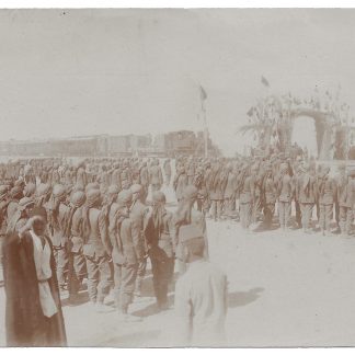
A rare collection of articles by different authors published in "La Nature" during the construction of the Hejaz Railway. These articles are important sources for understanding the European reception of the Hejaz Railway during its construction and also shed light on the technical building process. The second article in particular contains information about and illustrations of various railroad stations and their locations, including the geographic situation of al-Ula, north of Medina.
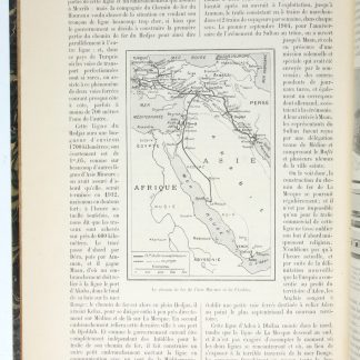
1) Henry Bougeois, "Le Chemin de Fer de La Mecque et Le Chemin de Fer d'Aden" (issue 1694, 11 November 1905, pp. 371f.). Introduces the Hejaz railway, announcing plans to extend the railway to Mecca. At the time of writing, the railway ran 600 km, but the project aimed to extend it to 1700 km. Bougeois explains how this goal was greeted with enthusiasm in the Muslim world and how quickly the necessary funds were raised to complete the project. He further explains the objectives of the project: to increase the Ottoman government's power in the region by facilitating the transfer of troops to the Arabian Peninsula in the wake of uprisings in Yemen, to minimize transportation costs, and to facilitate the Hajj by creating a safer road for pilgrims. A map in the text shows completed and unfinished sections.
2) R. Bonnin, "Le Chemin de Fer du Hejaz" (issue 1922, 26 March 1910, pp. 263-269). Describes the train route in more detail. By 1910 the railway had already reached Medina, 1300 km from Damascus, and the process of extending it to Mecca was underway. This article is concerned with the technical and topographical problems encountered in the construction of the railway and the further problems which the project might encounter during the process of building the extension. Bonnin carefully describes each station and gives detailed information on weather conditions, geographical formations, food and water shortages that might be encountered at these stations, and historical areas near the stations. These detailed descriptions focus on solutions found for geographical disadvantages: the Al-Ula station, for example, suffered from quicksand soil, and the rails were constantly filled with sand carried by the strong winds, and pebbles and clay were used on the platform to prevent this. With 9 illustrations and a map in the text, showing the completed railway between Damascus and Medina and the projected extension to Mecca. Illustrations includes historical sites such as the Hegra (al-Hijr) ruins, geographical formations in the valley of al-Ula, wells and forts used to store food and water near the stations of Katarne or al-Mu'assam, and a photo of the Al-Ula station with the train.
3) Issue 2115, 6 December 1913, p. 2. An editoral summary of an article on the Hejaz Railway by M. Blanckenhorn in the "Geographische Zeitschrift". Blanckenhorn had proposed an additional English trans-Arabian route to cut through Maah to Egypt, which would facilitate trade with Egypt. Comparing the economic advantages of Hejaz railway, the author insists that it would be unfortunate for the Turks to consider the railway solely as an instrument of military and religious power and to ignore the commercial and economic possibilities of the route.
Light exterior wear. Browning, stains, few paper tears not affecting the text. Overall clean and in good condition.
ZDB-ID 207100-9. OCLC 1367320756.
Related
-
Arabia, seu Arabum vicinarumque gentium Orientalium leges, ritus, sacri …Amsterdam, 1635.
€ 650.00 -
Begebenheiten einer Reise auf dem rothen Meer, auf der arabischen und ägyptischen …Leipzig, 1781.
€ 1,800.00 -
Road and rail map of Syria and Lebanon.Ottoman, 1911 CE = 1327 Rumi.
€ 3,500.00 -
[Original photograph of the Hejaz Railway, likely depicting an opening …Syria, Jordan or Arabian Peninsula, ca. 1908, or shortly before.
€ 2,500.00