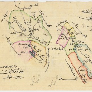
Manuscript map from the turbulent 20th century
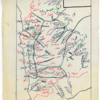
Manuscript map of administrative divisions and wadis of Yemen.
190 x 270 mm. Hand-drawn on tracing paper with black, red and green. In Arabic.
€ 800.00
A manuscript map from the turbulent 20th century of Yemeni history. Hand-drawn on tracing paper, the map shows the governorates of Yemen in green, cities and borders with Saudi Arabia and South Yemen in red, and some of its underlying geography in black, especially the wadis which stretch across the landscape from Aden to the Saudi Arabian border. Probably drawn by the hand of Saleh al-Khayrallah, whose name is at the top.
This map is interesting as a primary source of Yemen's constantly shifting regional borders and international borders during the 20th century. Numbers and names of administrative regions changed repeatedly, and new regions could be created by annexing various regions into others, especially between the years 1960 and 1980. In 1980, there were eight regions in total in North Yemen. This map shows only seven regions, indicating that it was drawn before that year. The seven governorates (liwas) are al-Bayda, al-Hudaydah, Hajjah, Ibb, Sa'dah, San'a', and Ta'izz (excluding al-Rida').
Light wear, very clean. A note at the bottom in a different hand, in red ink.