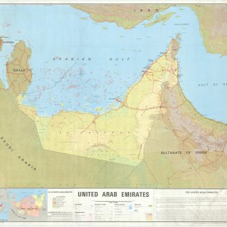
The newly founded Union: pearl fisheries and oil fields
United Arab Emirates. Oil in United Arab Emirates.
Colour-printed map, 962 x 1192 mm. Scale 1:750,000.
€ 25,000.00
The hitherto most detailed map of the newly formed United Arab Emirates, showing the undefined border with Saudi Arabia and the early border with Oman, each to be later contested, and featuring the earliest highway system and oil fields and pipelines. In the Gulf all of the UAE's pearling fields are highlighted in pink. Also marked are the crucial seaports at Abu Dhabi, Dubai, Sharjah, and Ras Al Khaimah, and the Liwa villages, the ancestral homeland of the Al Nahyan royal family of Abu Dhabi. Included is a table of oil production through 1972 and a small inset map of the concessions of oil companies, including Pan Ocean, Middle East, Abu Dhabi, Philips, and Bandaq Oil Companies, Dubai Petroleum Company, and Abu Dhabi Marine Areas. A fantastic record of a newly born country and the state of its infrastructure and oil industry at the time of unification.
Light wear, professionally reinforced and rebacked. Rare.
OCLC 5403061.
Related
-

Carte de l’Empire Ottoman comprenant les possessions de la Porte en Europe, …Paris, 1825.
€ 3,000.00 -
Arabia and the Persian Gulf. N.W. Section, S.W. Section. [Map of Arabia …Dehra Dun, 1916.
€ 8,500.00 -

Iran (Persia) and Iraq.London, 1930s.
€ 650.00 -

Voyage en Arabie & en d'autres Pays circonvoisins. Tome premier (-second). …Amsterdam & Utrecht, 1775-1780.
€ 6,000.00