History and geography of the Trucial Coast from a creator of the first ever map of the UAE
Imarat al-Sahil wa-Uman wa-al-Dawlah al-Saudiyah al-Ula 1818-1973 [The Emirates of the coast, Oman, and the First Saudi State 1818-1973].
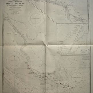
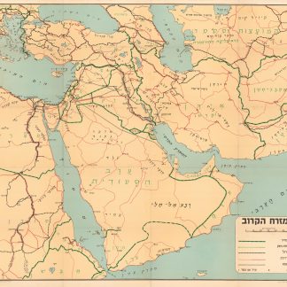
4to (177 x 254 mm). 334, (2) pp. With 2 folding maps and 23 plates. Also with seven 481 x 330 mm loose maps and charts in colour. Cream cloth in pictorial dust jacket showing a map of the Trucial Coast.
Authored by an expert in the field, the first and only edition of this scarce Arabic publication on the history of the coastal Emirates, Oman and the First Saudi State is one of the primary scholarly reference texts on the recent history of what would become the United Arab Emirates.
The work begins with detailed notes on the British Persian Gulf campaign of 1819, considered the beginning of British military and political control in the Gulf region. It was this conflict which led to the General Maritime Treaty of 1820, signed between the British and the Trucial sheikhs; what was then known to the British as the "Pirate Coast" would become known as the "Trucial Coast" after this treaty. Today, the territory once bound by the 1820 treaty comprises much of the United Arab Emirates, a landscape which is thoroughly mapped and photographed in the accompanying plates and materials. A fine collection of sources, from photos to treaties, all expertly explained, includes maps, plates, and sources drawn from British military diarists as well as Arabs.
The author, Muhammad Morsi Abdullah, was a leading historian of the emergence of the United Arab Emirates; he was awarded his doctorate at Cambridge for a thesis on the modern history of the UAE, after which he returned to his work in Abu Dhabi as Director of the Documentation and Studies Center in the Office of the President of the United Arab Emirates. In 1969, Abdullah published the book "Abu Dhabi Between Yesterday and Today", as well as a map of the emirate of Abu Dhabi. In 1972, he participated in the crucial project of making the first map of the United Arab Emirates itself. Fittingly, the present work was issued with seven large maps and charts alongside the book, which is itself illustrated with two folding maps and numerous photographic plates providing a visual history of the UAE. Scarce, with only two copies listed in institutions on OCLC.
Small stain on dust jacket; loose maps with very minor edgewear or creasing. A handsome copy in dust jacket and with all accompanying materials.
Cf. OCLC 1230033402, 1044576059.