![[UK Admiralty Charts: The Arabian Gulf].](https://inlibris.com/wp-content/uploads/2024/05/img-bn63420.jpg)
![[UK Admiralty Charts: The Arabian Gulf]. - Image 2](https://inlibris.com/wp-content/uploads/2024/05/img-bn63420-a.jpg)
![[UK Admiralty Charts: The Arabian Gulf]. - Image 3](https://inlibris.com/wp-content/uploads/2024/05/img-bn63420-b.jpg)
![[UK Admiralty Charts: The Arabian Gulf]. - Image 4](https://inlibris.com/wp-content/uploads/2024/05/img-bn63420-c.jpg)
![[UK Admiralty Charts: The Arabian Gulf]. - Image 5](https://inlibris.com/wp-content/uploads/2024/05/img-bn63420-d.jpg)
[UK Admiralty Charts: The Arabian Gulf].
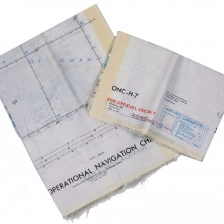
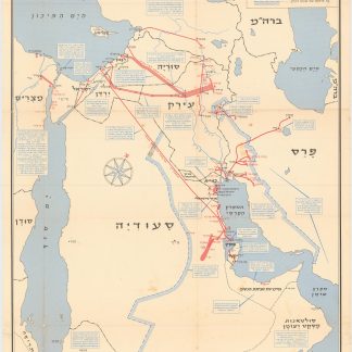
4 hydrographic charts. 710 x 863 mm to 710 x 1035 mm. Scale 1:350,000. Lights and beacons indicated in purple.
€ 2,000.00
A fine set of nautical charts of the Arabian Gulf, including one Decca chart, covering the northern end of the Gulf, Ras Tanura in Saudi Arabia, and the Strait of Hormuz with the Gulf of Oman. Includes tidal information, compass roses, oil rigs, loading and pipeline terminals, soundings, seabed notations, currents, sandbanks, shoals, and inland elevations (including a "conspicuous tree" on the island of Shaikh Shu'aib). First issued between 1955 and 1962 respectively, the present charts are enhanced editions from 1976. The practice was to print an initial edition based on a major hydrographic survey, and then to overprint them with subsequent data as it became available.
The maps are as follows: Ras At Tannura to Ras Al Qaliya (no. 2882); Jazh. Shaikh Shu'aib & Qalat to Ras at Tannura (no. 2883); Kalat and Ra's Al Khafji to Abadan (no. 2884); Ras Jask to Jazirat Sirri (no. 2888).
A few deletions by hand. Some creases along edges; otherwise very well preserved.
Related
-
![Geographic Map of the Central Persian Gulf Quadrangle Kingdom of Saudi Arabia. Miscellaneous Geologic Investigations Map I-209 A [and] B.](https://inlibris.com/wp-content/uploads/2020/05/img-bn49619-324x324.jpg)
Geographic Map of the Central Persian Gulf Quadrangle Kingdom of Saudi …Washington, D.C., 1959-1961 CE = 1378-1380 H.
€ 9,500.00 -
Persian Gulf. ONC-H-6/7. Operational navigation chart.St. Louis, 1969.
€ 2,800.00 -

Persian Gulf. ONC-H-6/7. Operational navigation chart.St. Louis, 1967.
€ 1,500.00 -
Neft ba-mizrah ha-tikhon. Zikaynot, shadot, tzinorot, batei zikuk. (Oil …Tel Aviv, 1957.
€ 5,000.00
![[UK Admiralty Charts: The Arabian Gulf].](https://inlibris.com/wp-content/uploads/2024/05/img-bn63420-324x324.jpg)