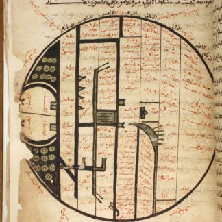
1623 Islamic world map in a manuscript attributed to al-Ghazali
Kitab Jawahir anwar wa ma'dan al-hukm wa al-asrar.
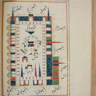
4to (165 x 220 mm). 276 ff. Arabic manuscript on unidentified watermarked paper. Brown maghribi script with titles and important words and phrases picked out in red. With two full-page diagrams of the Prophet's sandal and the world map. 19th century red morocco ruled in blind, with fore-edge flap.
€ 85,000.00
Previously unknown and unrecorded: an Arabic cosmographical treatise, illustrated with an exceedingly rare full-page Islamic map of the world, attributed by its scribe to the great Abu Hamid Muhammad al-Ghazali (ca. 1058-1111 CE). Perhaps the work of a Pseudo-Ghazali (or even the Renewer of the Faith himself), the manuscript was copied in 17th century North Africa, and comprises thirty-one chapters. These begin with a Muslim cosmogony, describing the creation of mankind and the Universe, and continue through fascinating sections which name and describe the continents, give an explanation of rivers and lakes, and include a chapter on all the countries from China to Al-Andalus. Other chapters focus on distinct features in the world, such as Egypt, the Nile, and the great cities of Mecca, Medina, and Alexandria, while still others describe to the reader what can be found in the wide world of God's Creation: the clothing of different peoples (with notes on material, dying, coloring, silk, fur, etc), the use and source of perfumes such as rosewater, musk and ambergris; different breeds of horses, and indeed different horse saddles and gear; foods, spices, and expensive delicacies like saffron and rare dates; books and the different arts of writing, and even politics and good manners.
At the centre of this wide-ranging cosmography is the world map, which is presented in the ancient form of historical Islamic map-making, which has medieval roots. The map is circular, representing the sphere of the planet, arranged with East at the top of the page. It is divided into the seven climate zones with vertical (and thus East-West) lines, an inheritance from the Classical world through Arabic translations of Ptolemy, and marks the farthest North or South the sun rises on the summer and winter solstices. The design of the continents and seas is entirely abstract and stylized, harkening back to the oldest map-making styles of the Muslim world, with locations largely clarified through extensive labels, and of course the city of Mecca at the centre of the 4th (and best for living) climate zone, and thus the centre of the world.
World maps are notably rare in manuscripts, especially those which remain in situ, rather than cut and removed from their codices over the centuries. The attribution of the work itself to al-Ghazali, along with a statement on p. 22 that this manuscript was copied from the original copy of this treatise, are equally fascinating, and suggest that this African manuscript could greatly benefit from scholarly attention.
Previously in a French collection, with French notes identifying the manuscript inked on the front cover and spine.
Professional paper repairs throughout, most marginal, a few affecting very small (one word or so) portions of text.
Related
-
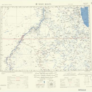
Wadi Halfa. 1301 (GSGS 4646). Edition 4. Sheet NF-36.Giza, Egypt, 1947.
€ 500.00 -
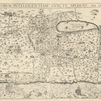
Situs Terrae Promissionis SS Bibliorum Intelligentiam Exacte Aperiens: …Cologne, 1682.
€ 2,000.00 -
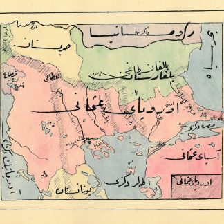
Manuscript map album of the Ottoman Empire.Ottoman Empire, ca. 1910.
€ 8,500.00 -
Futuh al-Haramayn [Description of the Holy Cities].India or Persia, late 19th or early 20th century CE.
€ 35,000.00