


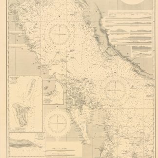
Road Map Eastern Province Saudi Arabia. B-2260B.
No place, 1963 / 1978.
860 x 1150 x mm. Scale: 1:500,000.
€ 3,500.00
Road map of the eastern province of Saudi Arabia, south of Kuwait, including the Neutral Zone, Bahrain and a portion of Qatar. The map indicates onshore and offshore oil fields such as Ghwara, Dammam, Qatif, Abu Hadriyah, Safaniya and Khafji, along with towns, villages, roads, tracks, pipelines, wells and power lines.
First printed in August 1963, the chart saw several revisions, the present one dating from August 1978 - a time when offshore discoveries put increasing pressure on the Gulf states to draw distinct international boundaries.
Condition
Some smaller tears along margins and folds; two repaired with adhesive tape. Somewhat toned.
Related
-
![Jazirat al-'Arab wa-al-manatiq al-mutakhimah la-ha: kharitah tamhidiyah [The Arabian Peninsula and neighboring regions: an introductory map]. G-1-AA-1.](https://inlibris.com/wp-content/uploads/2021/04/img-bn53470-324x324.jpg)
Jazirat al-'Arab wa-al-manatiq al-mutakhimah la-ha: kharitah tamhidiyah …Dharan, 1950-52 CE = 1369-71 H.
€ 4,500.00 -
![Geographic Map of the Central Persian Gulf Quadrangle Kingdom of Saudi Arabia. Miscellaneous Geologic Investigations Map I-209 A [and] B.](https://inlibris.com/wp-content/uploads/2020/05/img-bn49619-324x324.jpg)
Geographic Map of the Central Persian Gulf Quadrangle Kingdom of Saudi …Washington, D.C., 1959-1961 CE = 1378-1380 H.
€ 9,500.00 -
Persian Gulf. Western Sheet. No. 2837b.London, 1948.
€ 1,500.00 -
North East Rub Al Khali. B-1583-X.Saudi Arabia, 1953.
€ 2,800.00
